IMAGES TAKEN NEAR TO
Hall Road, COLCHESTER, CO6 3DS
Introduction
This page details the photographs taken nearby to Hall Road, CO6 3DS by members of the Geograph project.
The Geograph project started in 2005 with the aim of publishing, organising and preserving representative images for every square kilometre of Great Britain, Ireland and the Isle of Man.

There are currently over 7.5m images from over14,400 individuals and you can help contribute to the project by visiting https://www.geograph.org.uk
Image Map
Images are licensed for reuse under creativecommons.org/licenses/by-sa/2.0
Notes
- Clicking on the map will re-center to the selected point.
- The higher the marker number, the further away the image location is from the centre of the postcode.
Image Listing (6 Images Found)
Images are licensed for reuse under creativecommons.org/licenses/by-sa/2.0
Image
Details
Distance
1
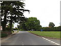
Entering West Bergholt on Nayland Road
At the junction with the B1508 Colchester Road and Lexden Road
Image: © Geographer
Taken: 14 May 2016
0.20 miles
2
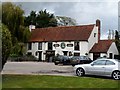
White Hart pub
A C17 building. See http://www.britishlistedbuildings.co.uk/en-421400-the-white-hart-public-house-west-berghol for entry in British Listed Buildings.
Image: © Bikeboy
Taken: 11 Oct 2014
0.20 miles
3
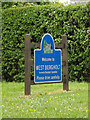
West Bergholt Village Name sign
Off the B1508 Colchester Road at the junction with Nayland and Lexden Roads
Image: © Geographer
Taken: 14 May 2016
0.20 miles
5
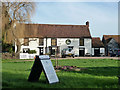
The White Hart, West Bergholt
A grade II listed building, considered to be 17th century in the citation, but on the front of the pub a more modest claim is made of 'circa 1725'.
Image: © Robin Webster
Taken: 13 Jan 2016
0.21 miles
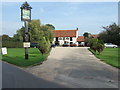
6
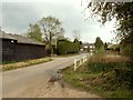
Part of Hall Road in West Bergholt
This is the end of Hall Road as it is about to join Lexden Road.
Image: © Robert Edwards
Taken: 2 May 2008
0.22 miles