IMAGES TAKEN NEAR TO
Swan Grove, COLCHESTER, CO6 2DU
Introduction
This page details the photographs taken nearby to Swan Grove, CO6 2DU by members of the Geograph project.
The Geograph project started in 2005 with the aim of publishing, organising and preserving representative images for every square kilometre of Great Britain, Ireland and the Isle of Man.

There are currently over 7.5m images from over14,400 individuals and you can help contribute to the project by visiting https://www.geograph.org.uk
Image Map
Images are licensed for reuse under creativecommons.org/licenses/by-sa/2.0
Notes
- Clicking on the map will re-center to the selected point.
- The higher the marker number, the further away the image location is from the centre of the postcode.
Image Listing (99 Images Found)
Images are licensed for reuse under creativecommons.org/licenses/by-sa/2.0
Image
Details
Distance
1
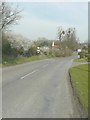
Approaching Chappel from the southwest.
With the spire of St Barnabas’ church visible in the distance.
Image: © John Baker
Taken: 29 Mar 2014
0.06 miles
2
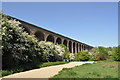
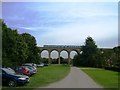
Chappel Viaduct
The Chappel viaduct is 325 metres long, has 32 arches of 30 9 metre span and its maximum height is 23 metres. It currently takes the Marks Tey to Sudbury branch line, which connects regularly with trains to and from London's Liverpool Street Station.
The large number of construction workers needed for the project were housed, many with their families, in temporary huts built on Wakes Colne Green. Although some 7 million bricks were used, the piers were hollow to save money and reduce weight. A further remarkable feature of the viaduct is that it is built on a gradient - the Sudbury end is 2.9 metres higher than the Marks Tey end. According to William White’s History, Gazetteer and Directory of the County of Essex, 1848, the first stone was laid in September 1847. The viaduct took two years to build, and is thought to be the second largest brick-built structure in England.
The first passenger train to Sudbury, carrying an official party from Colchester, ran on 2 July 1849. (wikipedia)
Image: © Ashley Dace
Taken: 27 Apr 2011
0.07 miles
3
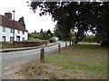
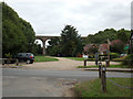
Chapel Hill, Wakes Colne
At the junction with The Street & entrance to Viaduct Farm
Image: © Geographer
Taken: 18 Aug 2018
0.07 miles
4
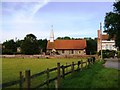
St Barnabas Chapel, Chappel, Essex
Houses cluster around the small 14th century church, originally a chapel. The village was allowed a chapel of its own in 1355, because bad weather prevented attendance at church - hence the name.
Image: © Brenda Howard
Taken: 28 Sep 2005
0.07 miles
5
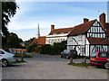
Chappel Village, Essex
Small quaint village in the valley of the River Colne and in the shadow of the biggest viaduct in East Anglia.
Image: © Brenda Howard
Taken: 28 Sep 2005
0.07 miles
6
Chappel Viaduct, Near Wakes Colne, Essex
Train crossing the viaduct, travelling towards the small Chappel and Wakes Colne Railway Station. Photographer facing E'SE, train travelling N'NE.
Image: © Brenda Howard
Taken: 28 Sep 2005
0.08 miles
7
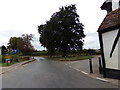
The Street, Wakes Colne
At the junction with Chapel Hill & entrance to Viaduct Farm
Image: © Geographer
Taken: 18 Aug 2018
0.08 miles
8
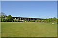
Chappel Viaduct
The Chappel viaduct is 325 metres long, has 32 arches of 30 9 metre span and its maximum height is 23 metres. It currently takes the Marks Tey to Sudbury branch line, which connects regularly with trains to and from London's Liverpool Street Station.
The large number of construction workers needed for the project were housed, many with their families, in temporary huts built on Wakes Colne Green. Although some 7 million bricks were used, the piers were hollow to save money and reduce weight. A further remarkable feature of the viaduct is that it is built on a gradient - the Sudbury end is 2.9 metres higher than the Marks Tey end. According to William White’s History, Gazetteer and Directory of the County of Essex, 1848, the first stone was laid in September 1847. The viaduct took two years to build, and is thought to be the second largest brick-built structure in England.
The first passenger train to Sudbury, carrying an official party from Colchester, ran on 2 July 1849. (wikipedia)
Image: © Ashley Dace
Taken: 27 Apr 2011
0.08 miles
9
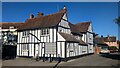
Raynham House
https://historicengland.org.uk/listing/the-list/list-entry/1274015?section=official-list-entry
Image: © Sandy Gerrard
Taken: 24 Oct 2024
0.09 miles
10
Chappel Viaduct
Taken from The Street at the junction with Chapel Hill & entrance to Viaduct Farm
Image: © Geographer
Taken: 18 Aug 2018
0.09 miles