IMAGES TAKEN NEAR TO
Westfield Drive, COLCHESTER, CO6 1PU
Introduction
This page details the photographs taken nearby to Westfield Drive, CO6 1PU by members of the Geograph project.
The Geograph project started in 2005 with the aim of publishing, organising and preserving representative images for every square kilometre of Great Britain, Ireland and the Isle of Man.

There are currently over 7.5m images from over14,400 individuals and you can help contribute to the project by visiting https://www.geograph.org.uk
Image Map
Images are licensed for reuse under creativecommons.org/licenses/by-sa/2.0
Notes
- Clicking on the map will re-center to the selected point.
- The higher the marker number, the further away the image location is from the centre of the postcode.
Image Listing (5 Images Found)
Images are licensed for reuse under creativecommons.org/licenses/by-sa/2.0
Image
Details
Distance
1
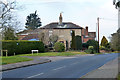
Quaker Cottage, Tilkey Road, Coggeshall
One of the older houses in this part of Coggeshall. There is a tiny Friends' Burial Ground off to the left, hemmed in by modern development, and seemingly only accessible though the garden of this house.
Image: © Robin Webster
Taken: 15 Feb 2015
0.17 miles
2
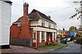
Former Public House, Tilkey, Coggeshall
There are still several pubs in Coggeshall, but previously there were many more. Several, like this one - now a private house - were in operation into the 70's when I lived locally, but have since closed. Unfortunately I can't remember the name with certainty even though I drank there a few times; it may have been called 'The Lamb.'
Image: © Trevor Harris
Taken: 27 Oct 2009
0.18 miles
3
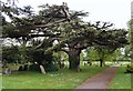
Old Cedar
Tree in the extensive and quite well-wooded graveyard of St. Peter ad Vincula
Image: © John Myers
Taken: 27 Apr 2014
0.18 miles
4
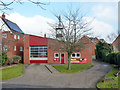
Coggeshall Fire Station
On Colne Road.
Image: © Robin Webster
Taken: 15 Feb 2015
0.20 miles
5
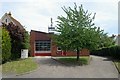
Coggeshall fire station
Coggeshall fire station, Colne Road, Coggeshall, Colchester, Essex
Image: © Kevin Hale
Taken: 5 Jun 2010
0.20 miles