IMAGES TAKEN NEAR TO
Thompson Gardens, CO6 1GF
Introduction
This page details the photographs taken nearby to Thompson Gardens, CO6 1GF by members of the Geograph project.
The Geograph project started in 2005 with the aim of publishing, organising and preserving representative images for every square kilometre of Great Britain, Ireland and the Isle of Man.

There are currently over 7.5m images from over14,400 individuals and you can help contribute to the project by visiting https://www.geograph.org.uk
Image Map
Images are licensed for reuse under creativecommons.org/licenses/by-sa/2.0
Notes
- Clicking on the map will re-center to the selected point.
- The higher the marker number, the further away the image location is from the centre of the postcode.
Image Listing (14 Images Found)
Images are licensed for reuse under creativecommons.org/licenses/by-sa/2.0
Image
Details
Distance
1
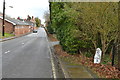
Old Milepost
Old milepost at Coggeshall, Essex for close up view see http://www.geograph.org.uk/photo/4312786
Image: © Keith Evans
Taken: 11 Dec 2014
0.09 miles
2
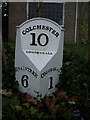
Old Milepost by West Street, Coggeshall
Cast iron post by the UC road, in parish of COGGESHALL (BRAINTREE District), West Street, by No. 125, by the road, on South side of road. Erected by the Coggeshall & Bocking (Div. of Essex First Dist) turnpike trust in the 19th century.
Inscription reads:-
: BRAINTREE / 6 : : COLCHESTER / 10 / COGGESHALL : : COGGESHALL / 1 :
Grade II listed.
List Entry Number: 1123897 https://historicengland.org.uk/listing/the-list/list-entry/1123897
Milestone Society National ID: EX_COBT10.
Image: © JV Nicholls
Taken: Unknown
0.09 miles
3
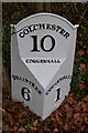
Old Milepost
Old milepost at Coggeshall, Essex for over all view see http://www.geograph.org.uk/photo/4312793
Image: © Keith Evans
Taken: 11 Dec 2014
0.09 miles

5
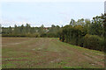
Countryside to the South East of Coggeshall
As seen from the Essex Way
Image: © Chris Heaton
Taken: 14 Oct 2020
0.20 miles
6
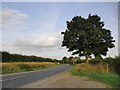
Minor road approaching Coggeshall from the west
Now a minor road, but previously the main road from Braintree to Colchester - which means it must lie close to the alignment of Roman Stane Street.
Image: © Stefan Czapski
Taken: 5 Sep 2015
0.20 miles
7
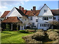
Paycocke's House, Coggeshall
Ancient NT house seen from the back garden.
Image: © Richard Slessor
Taken: 4 Apr 2006
0.22 miles
8
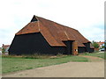
Coggeshall Grange Barn
Coggeshall Grange Barn Essex. 13th -century monastic barn. Restored in the 1980s by the Coggeshall Grange Barn Trust.
Image: © Keith Evans
Taken: 22 Aug 2006
0.22 miles
9
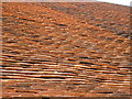
Up on the roof
The many pantiles on Coggeshall Grange Barn, Essex. 13th-century monastic barn. Restored in the 1980s by the Coggeshall Grange Barn Trust.
Image: © Keith Evans
Taken: 22 Aug 2006
0.22 miles
10
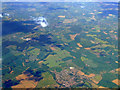
Coggleshall from the air
The former RAF Earls Colne Airfield (now mostly a golf course) can be seen to the left of centre of the photo.
Here is a http://en.wikipedia.org/wiki/Earls_Colne_Airfield to the wikipedia article about Earls Colne Airfield.
Image: © Thomas Nugent
Taken: 9 May 2011
0.22 miles