IMAGES TAKEN NEAR TO
Coggeshall Road, COLCHESTER, CO5 9PH
Introduction
This page details the photographs taken nearby to Coggeshall Road, CO5 9PH by members of the Geograph project.
The Geograph project started in 2005 with the aim of publishing, organising and preserving representative images for every square kilometre of Great Britain, Ireland and the Isle of Man.

There are currently over 7.5m images from over14,400 individuals and you can help contribute to the project by visiting https://www.geograph.org.uk
Image Map
Images are licensed for reuse under creativecommons.org/licenses/by-sa/2.0
Notes
- Clicking on the map will re-center to the selected point.
- The higher the marker number, the further away the image location is from the centre of the postcode.
Image Listing (2 Images Found)
Images are licensed for reuse under creativecommons.org/licenses/by-sa/2.0
Image
Details
Distance
1
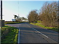
Pantling's Lane joins the B1024
Partly metalled road (at this eastern end) but mainly a narrow bridleway, Pantling's Lane runs westwards from this point to the former boundary of the Rivenhall airfield. In all probability, it originally went further west, but the construction of the airfield in 1946 would have put paid to that.
Image: © Richard Law
Taken: 6 Apr 2016
0.15 miles
2
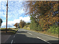
B1024 Coggeshall Road, Kelvedon
Approaching the junction with Pantlings Lane
Image: © Geographer
Taken: 5 Oct 2019
0.21 miles