IMAGES TAKEN NEAR TO
Braddy Court, COLCHESTER, CO5 9JP
Introduction
This page details the photographs taken nearby to Braddy Court, CO5 9JP by members of the Geograph project.
The Geograph project started in 2005 with the aim of publishing, organising and preserving representative images for every square kilometre of Great Britain, Ireland and the Isle of Man.

There are currently over 7.5m images from over14,400 individuals and you can help contribute to the project by visiting https://www.geograph.org.uk
Image Map (Loading...)


Getting Data...Please wait
Leaflet Map data © OpenStreetMap
Images are licensed for reuse under creativecommons.org/licenses/by-sa/2.0
Notes
- Clicking on the map will re-center to the selected point.
- The higher the marker number, the further away the image location is from the centre of the postcode.
Image Listing (38 Images Found)
Images are licensed for reuse under creativecommons.org/licenses/by-sa/2.0
Image
Details
Distance
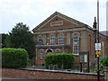
1
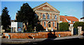
United Reformed Church, Kelvedon, Essex
Image: © Peter Stack
Taken: 27 Jan 2009
0.01 miles
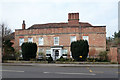
2
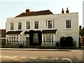
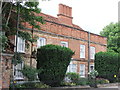
The Lawn House, Kelvedon, Essex
This house stands on Kelvedon High Street.
Image: © Robert Edwards
Taken: 15 Mar 2006
0.01 miles
3
United Reformed Church, Kelvedon
Erected as a Congregational Chapel in 1853.
Image: © Robin Webster
Taken: 15 Feb 2015
0.02 miles
4
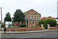
Kelvedon United Reformed Church
Over the wall...
Image: © nick macneill
Taken: 24 Mar 2012
0.02 miles
5
United Reformed Church, Kelvedon
This church was formerly the Congregational Chapel built in 1853.
Image: © PAUL FARMER
Taken: 13 Jun 2010
0.02 miles
6
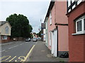
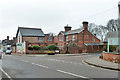
Kelvedon Conservative Club
Kelvedon Conservative Club is at 84 High Street
Image: © PAUL FARMER
Taken: 13 Jun 2010
0.03 miles
7
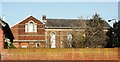
The Institute
A public hall built in 1911. Among other things it is an excellent monthly live music venue (Live At The Institute).
Image: © Trevor Harris
Taken: 16 Feb 2013
0.04 miles
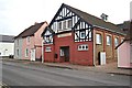
8
Ormonde House, High Street, Kelvedon
A grade II listed building of 16th century origin, altered over the years.
Image: © Robin Webster
Taken: 15 Feb 2015
0.04 miles
9
Ormonde House, High Street, Kelvedon
This is a 16th or early 17th century timber framed house with a 18th century brick front
Image: © PAUL FARMER
Taken: 13 Jun 2010
0.04 miles
10
87 High Street, Kelvedon
This was the parsonage for the chapel whose name board may just be seen on the other corner of New Road. It seems to date from about 1900. Previously there was a 'Manse' mapped here in the 1870s, but a later mapping in the 1890s shows a vacant site, so this is presumably a replacement.
Beyond is a Co-op Foodstore.
Image: © Robin Webster
Taken: 15 Feb 2015
0.04 miles