IMAGES TAKEN NEAR TO
Breeze Lane, COLCHESTER, CO4 5XU
Introduction
This page details the photographs taken nearby to Breeze Lane, CO4 5XU by members of the Geograph project.
The Geograph project started in 2005 with the aim of publishing, organising and preserving representative images for every square kilometre of Great Britain, Ireland and the Isle of Man.

There are currently over 7.5m images from over14,400 individuals and you can help contribute to the project by visiting https://www.geograph.org.uk
Image Map
Images are licensed for reuse under creativecommons.org/licenses/by-sa/2.0
Notes
- Clicking on the map will re-center to the selected point.
- The higher the marker number, the further away the image location is from the centre of the postcode.
Image Listing (5 Images Found)
Images are licensed for reuse under creativecommons.org/licenses/by-sa/2.0
Image
Details
Distance
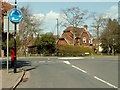
2
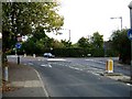
Bakers Lane & Braiswick
This is the Junction of the B1508 in Braiswick and Bakers lane (to the right).
Bakers Lane runs from here to Lexden west of Colchester town centre. The grid reference is for the 43m Spot Height that is plumb under the mini roundabout. The picture was taken looking towards Colchester.
Image: © Glyn Baker
Taken: 22 Oct 2005
0.23 miles
4
Mini-roundabout on the B1508 at Braiswick
The approach road is Baker's Lane.
Image: © Robert Edwards
Taken: 16 Apr 2008
0.25 miles