IMAGES TAKEN NEAR TO
Tumulus Way, COLCHESTER, CO2 9SD
Introduction
This page details the photographs taken nearby to Tumulus Way, CO2 9SD by members of the Geograph project.
The Geograph project started in 2005 with the aim of publishing, organising and preserving representative images for every square kilometre of Great Britain, Ireland and the Isle of Man.

There are currently over 7.5m images from over14,400 individuals and you can help contribute to the project by visiting https://www.geograph.org.uk
Image Map
Images are licensed for reuse under creativecommons.org/licenses/by-sa/2.0
Notes
- Clicking on the map will re-center to the selected point.
- The higher the marker number, the further away the image location is from the centre of the postcode.
Image Listing (22 Images Found)
Images are licensed for reuse under creativecommons.org/licenses/by-sa/2.0
Image
Details
Distance
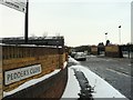
3

Blue shop, Shrub End Road
Certainly eye catching, which is probably the idea. Mankin Models.
Image: © Robin Webster
Taken: 17 Jan 2016
0.08 miles
4
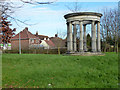
'Roman' temple on edge of town
On a bit of green by the Maldon Road - Cunobelin Way - Shrub End Road roundabout.
Image: © Robin Webster
Taken: 17 Jan 2016
0.09 miles
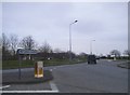
6
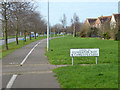
Cunobelin Way cycle and foot path
Colchester can't get over the fact it was a Roman town.
Image: © Robin Webster
Taken: 17 Jan 2016
0.10 miles
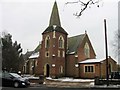
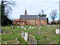
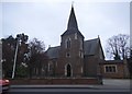
9

All Saints Church Colchester Essex
Situated at the junction of Shrub End Road and Gosbecks Road.
Image: © Peter Stack
Taken: 22 Jun 2009
0.13 miles