IMAGES TAKEN NEAR TO
Berechurch Road, COLCHESTER, CO2 7QB
Introduction
This page details the photographs taken nearby to Berechurch Road, CO2 7QB by members of the Geograph project.
The Geograph project started in 2005 with the aim of publishing, organising and preserving representative images for every square kilometre of Great Britain, Ireland and the Isle of Man.

There are currently over 7.5m images from over14,400 individuals and you can help contribute to the project by visiting https://www.geograph.org.uk
Image Map
Images are licensed for reuse under creativecommons.org/licenses/by-sa/2.0
Notes
- Clicking on the map will re-center to the selected point.
- The higher the marker number, the further away the image location is from the centre of the postcode.
Image Listing (23 Images Found)
Images are licensed for reuse under creativecommons.org/licenses/by-sa/2.0
Image
Details
Distance
1
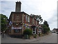
Former Britannia Inn, now restaurant, Meyrick Crescent, Colchester
Image: © David Smith
Taken: 31 May 2017
0.10 miles
2
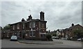
The Gurkha restaurant, in the former Britannia Inn
Image: © David Smith
Taken: 31 May 2017
0.11 miles
3
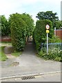
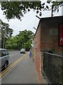
Footpath north from Meyrick Crescent, Colchester
Image: © David Smith
Taken: 31 May 2017
0.15 miles
4
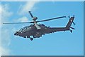
Air Corps Apache AH Mk1
Flypast by the Army Air Corps at the 2009 Colchester Military Festival http://www.gazette-news.co.uk/news/9495706.Military_show_will_rise_from_the_ashes/r/?ref=rss on Abbey Field. The Abbey Field is used as a public open space and is managed by the Garrison. learn more about the aircraft at http://www.army.mod.uk/equipment/aircraft/1531.aspx
Image: © Glyn Baker
Taken: 18 Jul 2009
0.16 miles
5
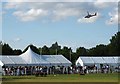
Abbey Field and Apache
Flypast by the Army Air Corps at the 2009 Colchester Military Festival http://www.gazette-news.co.uk/news/9495706.Military_show_will_rise_from_the_ashes/r/?ref=rss on Abbey Field. The Abbey Field is used as a public open space and is managed by the Garrison. For a closer look at the helicopter see Image
Image: © Glyn Baker
Taken: 18 Jul 2009
0.16 miles
6
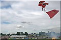
Abbey Field Aerial Access
Here the Parachute Regiment Display Team the Red Devils http://www.reddevilsonline.com/about_us pay a visit to the arena of the 2009 Colchester Military Festival http://www.eventplan.co.uk/CMF09.htm on Abbey Field. The Abbey Field is used as a public open space and is managed by the Garrison.
Image: © Glyn Baker
Taken: 18 Jul 2009
0.16 miles
7
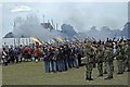
Accompaniment to the Artillery
This is the Abbey Field Colchester during the finale of the 2009 Colchester Military festival. Various re-enactment groups from various periods of history from the Spartans through to WW2 were assisting the 7th (Parachute) Regiment Royal Horse Artillery who were providing the cannon effects for an
Image The Abbey Field is used as a public open space and is managed by the Garrison.
Image: © Glyn Baker
Taken: 18 Jul 2009
0.16 miles
8
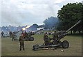
Abbey Field 1812
This is the Abbey Field Colchester during the finale of the 2009 Colchester Military festival. Here the 7th (Parachute) Regiment Royal Horse Artillery are providing the cannon effects for the closing bars of Tchaikovsky’s 1812 overture. Various re-enactment groups from other periods in history were providing Image The Abbey field is used a public open space maintained by the garrison.
Image: © Glyn Baker
Taken: 18 Jul 2009
0.16 miles
9
Wall with WD marker, Berechurch Road, Colchester
The WD marker reads: WD BS 35 27' in front
Image: © David Smith
Taken: 31 May 2017
0.19 miles
10
WD marker, Berechurch Road, Colchester
Image: © David Smith
Taken: 31 May 2017
0.19 miles