IMAGES TAKEN NEAR TO
Osborne Street, COLCHESTER, CO2 7DA
Introduction
This page details the photographs taken nearby to Osborne Street, CO2 7DA by members of the Geograph project.
The Geograph project started in 2005 with the aim of publishing, organising and preserving representative images for every square kilometre of Great Britain, Ireland and the Isle of Man.

There are currently over 7.5m images from over14,400 individuals and you can help contribute to the project by visiting https://www.geograph.org.uk
Image Map
Images are licensed for reuse under creativecommons.org/licenses/by-sa/2.0
Notes
- Clicking on the map will re-center to the selected point.
- The higher the marker number, the further away the image location is from the centre of the postcode.
Image Listing (383 Images Found)
Images are licensed for reuse under creativecommons.org/licenses/by-sa/2.0
Image
Details
Distance
1
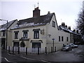
Scheregate Guesthouse, Osborne Street, Colchester
The Scheregate Guesthouse is sited opposite the Scheregate Steps.
Image: © PAUL FARMER
Taken: 4 Dec 2010
0.02 miles
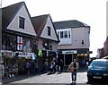
2
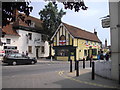
The Brewers Arms, public house, Osborne Street, Colchester
Image: © PAUL FARMER
Taken: 26 Jun 2010
0.02 miles
3
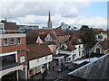
Looking down on St John's Street Colchester
The gap in the shops on the left leads to Shergate Steps
Image: © PAUL FARMER
Taken: 6 Nov 2010
0.02 miles
4
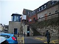
Vine Street steps Colchester
The steps lead from Vine Street car park to the shops above
Image: © PAUL FARMER
Taken: 15 Jan 2010
0.03 miles
5
Jacks Stores, Colchester
This is Jacks Stores in St Nicholas St/Culver St Colchester, purveyors since 1946 of Army Surplus stock, tools, hardware and almost any dry goods you can imagine all at pocket-money prices. Long may it remain out of the clutches of developers or national chains.
Image: © Glyn Baker
Taken: 25 Mar 2006
0.03 miles
6
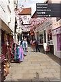
Scheregate Steps, Colchester
This is one of the medieval gateways cut through the Roman wall. When the photo was taken it was decorated with flags of St George for England because the Football World Cup was in progress.
Image: © David Hawgood
Taken: 15 Jun 2006
0.04 miles
7
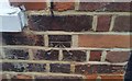
Ordnance Survey Cut Mark
This OS cut mark can be found on No8 Sir Isaac Walk. It marks a point 26.509m above mean sea level.
Image: © Adrian Dust
Taken: 7 Jan 2020
0.04 miles
8
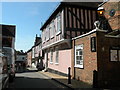
Trinity Street
C15 origin, L-shaped plan building with addition at south end. Considerably
restored. Grade II listed.
Image: © Keith Edkins
Taken: 6 Aug 2018
0.06 miles
9
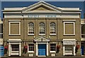
Colchester Baptist Church
Grade II listed building from 1834, described at this http://list.english-heritage.org.uk/resultsingle.aspx?uid=1306908.
Image: © Jim Osley
Taken: 3 Jul 2014
0.07 miles
10
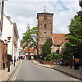
Holy Trinity Church, Colchester
Saxon church tower built about 1000; it incorporates some tiles and bricks from the Roman buildings.
Image: © David Hawgood
Taken: 15 Jun 2006
0.08 miles