IMAGES TAKEN NEAR TO
Hollingtons Grove, COLCHESTER, CO2 0PG
Introduction
This page details the photographs taken nearby to Hollingtons Grove, CO2 0PG by members of the Geograph project.
The Geograph project started in 2005 with the aim of publishing, organising and preserving representative images for every square kilometre of Great Britain, Ireland and the Isle of Man.

There are currently over 7.5m images from over14,400 individuals and you can help contribute to the project by visiting https://www.geograph.org.uk
Image Map
Images are licensed for reuse under creativecommons.org/licenses/by-sa/2.0
Notes
- Clicking on the map will re-center to the selected point.
- The higher the marker number, the further away the image location is from the centre of the postcode.
Image Listing (10 Images Found)
Images are licensed for reuse under creativecommons.org/licenses/by-sa/2.0
Image
Details
Distance
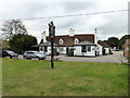
2
Hare & Hounds at Layer Bretton Heath
This is the Hare & Hounds at Layer Bretton Heath. The piece of green in the foreground is the only bit of ground that remotely resembles a heath now. Over the past 30 years due to lack of grazing and control of grass fires the view from the pub has changed from open grassland and bramble bushes to young broad leaf woodland.
Image: © Glyn Baker
Taken: 9 Oct 2005
0.13 miles

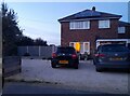
4
Birch Green
Garages behind Greenfield Houses.
Image: © Burgess Von Thunen
Taken: 18 Oct 2012
0.16 miles
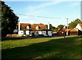
5
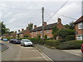
Greenfield Houses
1950s council houses.
Image: © Burgess Von Thunen
Taken: 18 Oct 2012
0.19 miles
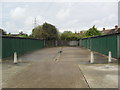
6
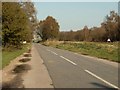
The road from Birch Green to Layer de la Haye
Image: © Robert Edwards
Taken: 16 Apr 2008
0.19 miles
7

Farmland near Birch
Ploughed field with Birch church in the background.
Image: © Burgess Von Thunen
Taken: 18 Oct 2012
0.21 miles
8
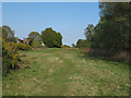
Layer Breton Heath
Layer Breton Heath is currently being actively restored to a more traditional heathland, with the thinning of birches and management of gorse: The intention is to restore a significant amount back to acid grassland, while retaining woodland and several large areas of scrub. See http://www.bretonheath.me.uk/LB-heath.htm http://www.webcitation.org/6GRJAokbg
Image: © Roger Jones
Taken: 6 May 2013
0.21 miles
9
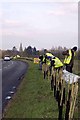
New Hedge In Birch Green
When I was a nipper I remember this hedge-line being grubbed up, encouraged by the policies and financial incentives of the Ministry of Agriculture. Today in order to qualify for the Higher Level Stewardship Scheme subsidies hedges are in fashion once more! http://www.naturalengland.gov.uk/ourwork/farming/funding/es/hls/default.aspx
Here volunteers from The Essex Wildlife Trust http://www.essexwt.org.uk/ Groundworks UK http://www.groundwork.org.uk/ and staff from Anglian Water (many thanks for the lunch folks!) are replanting the hedge with a mixture of native species. This is part of the Four Parishes Living Landscapes Project http://www.essexwt.org.uk/news/four_parishes_hedgerow_project/ that aims to restore four kilometres of hedgerow to provide a wildlife corridor between the dormice populations on Image and Image The landowners get free trees and labour in exchange for a commitment to maintain the new hedge. See the end of the days toil at Image and the results of a previous sortie at
Image
Image: © Glyn Baker
Taken: 27 Feb 2013
0.22 miles