IMAGES TAKEN NEAR TO
Hardys Green, COLCHESTER, CO2 0NZ
Introduction
This page details the photographs taken nearby to Hardys Green, CO2 0NZ by members of the Geograph project.
The Geograph project started in 2005 with the aim of publishing, organising and preserving representative images for every square kilometre of Great Britain, Ireland and the Isle of Man.

There are currently over 7.5m images from over14,400 individuals and you can help contribute to the project by visiting https://www.geograph.org.uk
Image Map
Images are licensed for reuse under creativecommons.org/licenses/by-sa/2.0
Notes
- Clicking on the map will re-center to the selected point.
- The higher the marker number, the further away the image location is from the centre of the postcode.
Image Listing (3 Images Found)
Images are licensed for reuse under creativecommons.org/licenses/by-sa/2.0
Image
Details
Distance
1
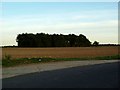
RADAR Spinney Birch Airfield
The picture was taken looking east from Blind Lane (see Image), which was one of the secondary runways of Birch Airfield south west of Colchester. From the name the stand of trees is clearly on the site of the airfield’s RADAR installation. Birch Airfield was built so late in the war it never became fully operational as a fighter or bomber station however it was attacked twice by the Luftwaffe. The history of Birch Airfield can be found at http://www.bretonheath.me.uk/history/airfield.htm The picture clearly shows the modern road surface on top of the concrete runway.
Image: © Glyn Baker
Taken: 9 Oct 2005
0.11 miles
2
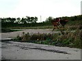
Dispersal At Birch
This is a picture of one of the dispersals at Birch Airfield South West of Colchester. Although never fully operational for combat aircraft the base was used for support, logistics and supply for other aerodromes particularly Image to the north (TL917306). Because of Its proximity to the unmistakable landmark of Abberton Reservoir Image Image it was used for emergency landings on a number of occasions by returning bombers. To go to the next field in an alphabetical tour of Essex WW2 airfields go to Image Much information as gleaned from Graham Smith’s book “Essex Airfields In The Second World War”. https://books.google.co.uk/books/about/Essex_Airfields_in_the_Second_World_War.html?id=u3atAAAACAAJ&redir_esc=y
Image: © Glyn Baker
Taken: 9 Oct 2005
0.13 miles
3
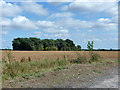
Radar Spinney
A name doubtless associated with the former RAF Birch, closed 1945. In the immediate foreground is the concrete at the north end of runway 02/20, now used by the public Blind Lane with a tarmac overlay and in an apparently narrowed form.
Image: © Robin Webster
Taken: 14 Aug 2015
0.17 miles