IMAGES TAKEN NEAR TO
High Road, COLCHESTER, CO2 0DY
Introduction
This page details the photographs taken nearby to High Road, CO2 0DY by members of the Geograph project.
The Geograph project started in 2005 with the aim of publishing, organising and preserving representative images for every square kilometre of Great Britain, Ireland and the Isle of Man.

There are currently over 7.5m images from over14,400 individuals and you can help contribute to the project by visiting https://www.geograph.org.uk
Image Map
Images are licensed for reuse under creativecommons.org/licenses/by-sa/2.0
Notes
- Clicking on the map will re-center to the selected point.
- The higher the marker number, the further away the image location is from the centre of the postcode.
Image Listing (8 Images Found)
Images are licensed for reuse under creativecommons.org/licenses/by-sa/2.0
Image
Details
Distance
1
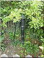
Pump, The Heath, Layer de la Haye
Of uncertain age, but certainly in the right place, as the spot was mapped as a well up to the 1950s, after which it was ignored, apart from, in later maps, the small enclosure. Oddly, the spout points away from the track.
Image: © Robin Webster
Taken: 16 Jul 2016
0.08 miles
2
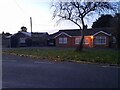
Bungalows on High Road, Layer-de-la-Haye
Image: © David Howard
Taken: 27 Oct 2024
0.12 miles
3
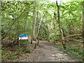
Entrance to Roman River Valley nature reserve
A path branching off the public footpath and following a stream running down to the Roman River.
Image: © Robin Webster
Taken: 16 Jul 2016
0.18 miles
4
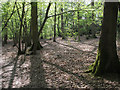
Needle Eye Wood, Roman River Valley Nature Reserve
This woodland, on rising ground, is just south of the Roman River.
For more info on the Roman River Valley Nature Reserve see http://www.webcitation.org/6GRIiM1VU
Image: © Roger Jones
Taken: 6 May 2013
0.20 miles
5
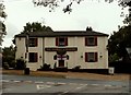
'The Donkey and Buskins' inn, Layer de la Haye, Essex
Image: © Robert Edwards
Taken: 26 Jun 2006
0.21 miles
6
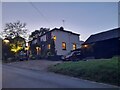
The Donkey and Buskins, Layer-de-la-Haye
Image: © David Howard
Taken: 27 Oct 2024
0.22 miles
7
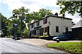
The Donkey and Buskins, Layer de la Haye
On the hill up from the Roman River.
Image: © Robin Webster
Taken: 16 Jul 2016
0.23 miles
8
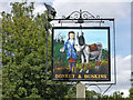
Inn sign, The Donkey and Buskins
For the pub, see Image
Image: © Robin Webster
Taken: 16 Jul 2016
0.23 miles