IMAGES TAKEN NEAR TO
Land Close, CLACTON-ON-SEA, CO16 8UJ
Introduction
This page details the photographs taken nearby to Land Close, CO16 8UJ by members of the Geograph project.
The Geograph project started in 2005 with the aim of publishing, organising and preserving representative images for every square kilometre of Great Britain, Ireland and the Isle of Man.

There are currently over 7.5m images from over14,400 individuals and you can help contribute to the project by visiting https://www.geograph.org.uk
Image Map (Loading...)


Getting Data...Please wait
Leaflet Map data © OpenStreetMap
Images are licensed for reuse under creativecommons.org/licenses/by-sa/2.0
Notes
- Clicking on the map will re-center to the selected point.
- The higher the marker number, the further away the image location is from the centre of the postcode.
Image Listing (9 Images Found)
Images are licensed for reuse under creativecommons.org/licenses/by-sa/2.0
Image
Details
Distance
1
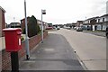
Peter Bruff Avenue
A street of typical 1970's vintage houses. I had an idle thought the post box looked rather modern in design, until I noticed the heavy corrosion on one of the seams. Gulp I must be getting old that didn't happen overnight !
Image: © Glyn Baker
Taken: 30 Sep 2023
0.04 miles
2
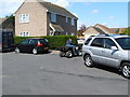
Unofficial Cycle Sales on St John's Road
A pop up bike shop by the side of the road.
Image: © Glyn Baker
Taken: 30 Sep 2023
0.10 miles
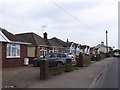
4
Looking down Marigold Avenue
Looking down Marigold Avenue on a nice sunny day in April 2006.
Image: © malcolm rayment
Taken: 30 Apr 2006
0.18 miles
5

Marigold Avenue on sunny April day 2006
Marigold Avenue Ruaton gardens, Clacton on sea, on sunny April day 2006
Image: © malcolm rayment
Taken: 30 Apr 2006
0.18 miles
6
Marigold Avenue, Turning point April 2006
Marigold Avenue, Ruaton Gardens Estate, Clacton On Sea, Essex Turning point April 2006
Image: © malcolm rayment
Taken: 30 Apr 2006
0.20 miles
7
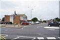
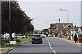
Shops at Bocking's Elm
To the left is Cloes Lane the 3rd exit off the mini roundabout would be Woodrow's Lane.
The main road is Image
Image: © Glyn Baker
Taken: 30 Sep 2023
0.22 miles
8
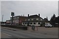
The Brace of Pistols inn, St Johns Road
Image: © David Smith
Taken: 31 May 2017
0.23 miles
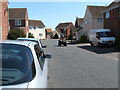
9
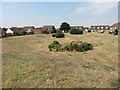
Southgreen Gardens
Raised public gardens surrounded by housing and accessible by road only from Ruaton Drive to the south. There are footpaths connecting them to the neighbouring residential streets: Lupin Way to the east and Camellia Crescent to the west.
Image: © Duncan Graham
Taken: 27 Jul 2018
0.24 miles