IMAGES TAKEN NEAR TO
Seawick Road, CLACTON-ON-SEA, CO16 8SJ
Introduction
This page details the photographs taken nearby to Seawick Road, CO16 8SJ by members of the Geograph project.
The Geograph project started in 2005 with the aim of publishing, organising and preserving representative images for every square kilometre of Great Britain, Ireland and the Isle of Man.

There are currently over 7.5m images from over14,400 individuals and you can help contribute to the project by visiting https://www.geograph.org.uk
Image Map
Images are licensed for reuse under creativecommons.org/licenses/by-sa/2.0
Notes
- Clicking on the map will re-center to the selected point.
- The higher the marker number, the further away the image location is from the centre of the postcode.
Image Listing (16 Images Found)
Images are licensed for reuse under creativecommons.org/licenses/by-sa/2.0
Image
Details
Distance
1
Caravan Site at Seawick
Hutley's Caravan Park (West).
Image: © Paul Franks
Taken: 2 Jul 2017
0.12 miles
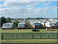
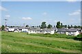
2
Seawick: Hutleys West Caravan Park
Hutleys started in business in 1921 and are the last remaining privately owned caravan park in the area. This is their West caravan park and the road in the middle is Third Avenue.
Image: © Nigel Cox
Taken: 28 Oct 2018
0.13 miles
3
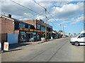
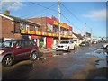
Seaview Road, Seawick
Amusement arcade on Seaview Road, Seawick.
Image: © Paul Franks
Taken: 2 Jul 2017
0.13 miles
4
Seawick: Seaview Road
Unsurprisingly old large scale Ordnance Survey maps show that the current day road layout in Seawick and its holiday village follows the old farm track and boundary layout from before development.
But the 1958 edition shows this road as Seawick Road, not Seaview Road, and with what appear to be permanent houses where the amusement arcades are now. In addition at the end of the road, at the junction with Beach Road, was a public house called The Monks Head. The public house building probably still exists but has in all likelihood been converted into an amusement arcade.
Image: © Nigel Cox
Taken: 28 Oct 2018
0.13 miles
5
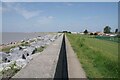
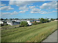
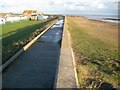
Sea Wall & Rip Rap Near Bel Air
Last time I was in this area there was a surfaced track running by the sea wall. At the time it was beginning to erode away. It has now totally vanished except for concrete rubble among the imported rocks.
Image: © Glyn Baker
Taken: 3 Jun 2023
0.14 miles
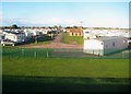
8
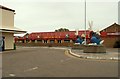
Chalet Park at Bel Air
Holiday homes in Seawick.
Image: © Glyn Baker
Taken: 3 Jun 2023
0.16 miles
9
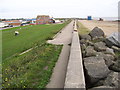
Seawick: Sea defence wall at St Osyth Beach
The sea defences seem to vary greatly in height throughout this section of the coast. In the foreground for example there is a significant step down. St Osyth beach is to the right.
Image: © Nigel Cox
Taken: 28 Oct 2018
0.19 miles