IMAGES TAKEN NEAR TO
Landermere, CLACTON-ON-SEA, CO16 0NL
Introduction
This page details the photographs taken nearby to Landermere, CO16 0NL by members of the Geograph project.
The Geograph project started in 2005 with the aim of publishing, organising and preserving representative images for every square kilometre of Great Britain, Ireland and the Isle of Man.

There are currently over 7.5m images from over14,400 individuals and you can help contribute to the project by visiting https://www.geograph.org.uk
Image Map
Images are licensed for reuse under creativecommons.org/licenses/by-sa/2.0
Notes
- Clicking on the map will re-center to the selected point.
- The higher the marker number, the further away the image location is from the centre of the postcode.
Image Listing (12 Images Found)
Images are licensed for reuse under creativecommons.org/licenses/by-sa/2.0
Image
Details
Distance
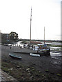
1
Landermere Quay
The old quay is viewed from the opposite side of the creek.
Image: © Bob Jones
Taken: 19 Mar 2011
0.03 miles
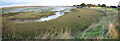
2
Landermere from Beaumont Quay
View of Landermere from the quay at Beaumont
Image: © Peter Pearson
Taken: 19 Jun 2005
0.05 miles
3
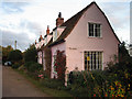
Gull Cottages, at the end of the track
This line of uniform pink cottages in an isolated settlement sat snugly beside the track and behind a line of trees, all that separated them from the marshes and the north wind. Currently, the first in the row is to let, as advertised on the yellow notice.
Image: © Zorba the Geek
Taken: 4 Nov 2007
0.05 miles
4
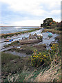
Small quay near the end of the creek
"Stenoa" is also in Image This is the view looking inland up towards the end of Landermere Creek.
Image: © Zorba the Geek
Taken: 4 Nov 2007
0.06 miles
5
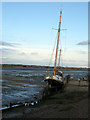
Yacht at a small quay on Landermere Creek
"Stenoa" at rest - but she'll refloat on the next high tide. The area of Hamford Water was fictionalised in Arthur Ransome's "Secret Water" http://en.wikipedia.org/wiki/Secret_Water
Image: © Zorba the Geek
Taken: 4 Nov 2007
0.06 miles
6
Old quay opposite Landermere
An ancient track leads across the saltings to the remains of an old quay, opposite Landermere Quay which can be seen on the other side of the creek.
Image: © Bob Jones
Taken: 19 Mar 2011
0.13 miles
7
Old mooring post in Landermere Creek
This mooring post is situated close to the remains of a former quay, opposite Landermere Quay which can be seen on the opposite side of the creek.
Image: © Bob Jones
Taken: 19 Mar 2011
0.15 miles
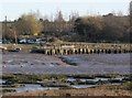
8
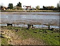
Boats of yesterday, boats of today
Rotting hulks of boats abandoned in the past lie stranded at the high tide line, while newer boats lie waiting for future action.
Image: © Zorba the Geek
Taken: 4 Nov 2007
0.17 miles
9
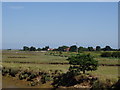
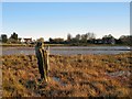
The very end of Landermere Creek
The boat in Image can be seen in the middle distance and beyond it is the settlement that contains Image, just visible through a gap in the trees. This panorama shows a sweep of the terrain typical of this area, from this point out towards the sea.
Image: © Zorba the Geek
Taken: 4 Nov 2007
0.18 miles
10
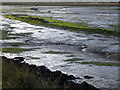
Colour contrasts at Landermere Creek
The low light of an autumn evening made the mud shine silver and the algae on the mud ridge glow green.
Image: © Zorba the Geek
Taken: 4 Nov 2007
0.18 miles