IMAGES TAKEN NEAR TO
Oak Close, CLACTON-ON-SEA, CO16 0HU
Introduction
This page details the photographs taken nearby to Oak Close, CO16 0HU by members of the Geograph project.
The Geograph project started in 2005 with the aim of publishing, organising and preserving representative images for every square kilometre of Great Britain, Ireland and the Isle of Man.

There are currently over 7.5m images from over14,400 individuals and you can help contribute to the project by visiting https://www.geograph.org.uk
Image Map
Images are licensed for reuse under creativecommons.org/licenses/by-sa/2.0
Notes
- Clicking on the map will re-center to the selected point.
- The higher the marker number, the further away the image location is from the centre of the postcode.
Image Listing (25 Images Found)
Images are licensed for reuse under creativecommons.org/licenses/by-sa/2.0
Image
Details
Distance
2
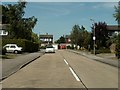
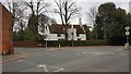
Abbey Street, Thorpe-le-Soken
The B1033 towards Frinton-on-Sea.
Image: © Robin Webster
Taken: 9 Feb 2019
0.05 miles
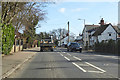
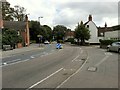
3
Thorpe-le-Soken: The War Memorial
Thorpe-le-Soken's War Memorial, with its three lamp posts, is on the junction of the B1033 Abbey Street, running left to right in the photograph, with the B1414 Station Road, entering from the right.
Image: © Nigel Cox
Taken: 15 Mar 2020
0.08 miles
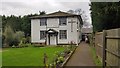
4
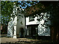
The Abbey, Thorpe-le-Soken
The Abbey, a large house in Abbey Street. A hanging sign above the entrance bears the date 1583.
Image: © Robin Lucas
Taken: 8 May 2008
0.09 miles
5
Thorpe-le-Soken: The Abbey
Occupying a prominent location at the junction of the B1033 High Street with the B1414 Landermere Road, The Abbey is a Grade II* Listed Building, the earliest parts of which date from the mid 16th Century. The Historic England website states that the house was first recorded in 1567 as Borowes, then as Gadlers in 1612, Brickhouse in 1690, Cage Farm in 1779, and finally The Abbey in 1795. There is however no mention on that website of any monastic or ecclesiastical connection.
Image: © Nigel Cox
Taken: 15 Mar 2020
0.12 miles
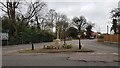
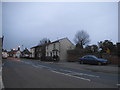
6
The junction of the B1033 with the B1414 in Thorpe-le-Soken
Image: © Roger A Smith
Taken: 12 Sep 2019
0.13 miles
9
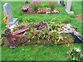
A floral tribute
Flowers marking a recent grave, of Ralph Lawrie, in the churchyard at Thorpe-le-Soken. With the centrepiece of sausages, beefburger and kebab, he was presumably a keen barbecue fan.
Image: © M J Richardson
Taken: 24 Aug 2007
0.18 miles
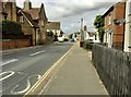
10
Thorpe-le-Soken: The Baptist Church
The Baptist Church is set back from the north side of the High Street, beyond another building.
It is a Grade II Listed, having been built in 1803. The front elevation here is roughcast, with the remainder, such as the one visible to the side, weatherboarded.
Image: © Nigel Cox
Taken: 15 Mar 2020
0.18 miles