IMAGES TAKEN NEAR TO
Vista Road, CLACTON-ON-SEA, CO15 6DY
Introduction
This page details the photographs taken nearby to Vista Road, CO15 6DY by members of the Geograph project.
The Geograph project started in 2005 with the aim of publishing, organising and preserving representative images for every square kilometre of Great Britain, Ireland and the Isle of Man.

There are currently over 7.5m images from over14,400 individuals and you can help contribute to the project by visiting https://www.geograph.org.uk
Image Map (Loading...)


Getting Data...Please wait
Leaflet Map data © OpenStreetMap
Images are licensed for reuse under creativecommons.org/licenses/by-sa/2.0
Notes
- Clicking on the map will re-center to the selected point.
- The higher the marker number, the further away the image location is from the centre of the postcode.
Image Listing (50 Images Found)
Images are licensed for reuse under creativecommons.org/licenses/by-sa/2.0
Image
Details
Distance
2
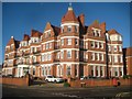
The Towers, Marine Parade East, Clacton
Late Victorian, for a period part of St. Osyth's Training College.
Image: © Robin Webster
Taken: 30 Oct 2016
0.04 miles
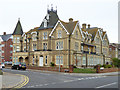
3
Clacton-on-Sea: The Towers
The Towers is on Marine Parade East. It is not a nationally Listed Building.
It was built in 1891 as The Towers Hotel, but never reopened after the Second World War. Instead it became a hall of residence for the St Osyth Training College, formerly The Grand Hotel, on the opposite side of Vista Road, before being converted into apartments.
Please see Robin Webster's Image] for a view taken from a similar position two years, bar a day, earlier.
Image: © Nigel Cox
Taken: 29 Oct 2018
0.04 miles
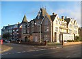
5
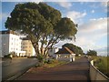
Clacton-on-Sea: The former Grand Hotel
The Grand Hotel was built here, on Marine Parade East, between 1892 and 1897. It is of steel box frame construction with red brick curtain walls, and, according to Historic England, is the earliest so far discovered with a complete and coherent internal structural steel system.
It was used by the military during the Second World War, and then converted to a teacher training college in 1950. It is shown on the 1952 and all later 20th Century large scale Ordnance Survey maps as St Osyth's Training College. It is known by Historic England as the Colchester Institute.
However in the early 2000s it was converted to apartments and renamed as just "The Grand".
It is a Grade II Listed Building and the Historic England website describes the east façade (the main one to the left, facing the sea) thus:-
"East front of 3 storeys and dormer attic; 19 window range. Symmetrical composition of 6 full-height projections, consisting of single polygonal turrets at the North and South ends, 2 3-window range bays with shaped gables inside these, and 2 central canted window bays. The 4 central projections separated by single-window bays. Facade horizontally divided at floor levels by rendered bands covering rolled steel joists and decorated with strapwork pargeting (many pargeted panels lost). Fenestration of 9/1 horned sashes to ground floor and 4/1 or 6/1 to next 2 floors, and 3/1 to the 3 pedimented dormers. All windows on lower 2 floors with tapering sash hoods. Central semi-circular porch, on 2 pairs of unfluted Doric columns. Double half-glazed doors beneath overlight with 4:8:4 panes. Cast-iron balconies between projections on first and second floors. 4 transverse stacks on front roof slope and additional stacks at oblique angles to North and South ends."
Image: © Nigel Cox
Taken: 29 Oct 2018
0.05 miles
6
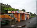
Clacton-on-Sea: Seafront shelter near St Paul's Road
Clacton has a great number of seafront shelters, all of which are of different designs. This one is at the seaward end of St Paul's Road.
The pavement along Marine Parade East here forms part of National Cycle Network Route 51.
Image: © Nigel Cox
Taken: 29 Oct 2018
0.06 miles
8
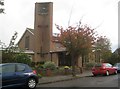
Clacton-on-Sea: St Paul's Church
The Church, on Church Road, was completed in about 1966, replacing an earlier one that originally dated from the 1870s, but which was not large enough and which suffered bomb damage during the Second World War. There is a photograph of the earlier church dated 1891 in the online Francis Frith collection.
Image: © Nigel Cox
Taken: 28 Oct 2018
0.07 miles
10
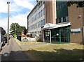
Colchester Institute Clacton Campus
This photograph shows the entrance to the Clacton Campus of Colchester Institute on Church Road, Clacton.
The Clacton Campus opened in 1976 at the formation of Colchester Institute, when North East Essex Technical College merged with St Osyth Training College.
Image: © Duncan Graham
Taken: 30 Jul 2018
0.08 miles