IMAGES TAKEN NEAR TO
Kings Parade, CLACTON-ON-SEA, CO15 5JA
Introduction
This page details the photographs taken nearby to Kings Parade, CO15 5JA by members of the Geograph project.
The Geograph project started in 2005 with the aim of publishing, organising and preserving representative images for every square kilometre of Great Britain, Ireland and the Isle of Man.

There are currently over 7.5m images from over14,400 individuals and you can help contribute to the project by visiting https://www.geograph.org.uk
Image Map
Images are licensed for reuse under creativecommons.org/licenses/by-sa/2.0
Notes
- Clicking on the map will re-center to the selected point.
- The higher the marker number, the further away the image location is from the centre of the postcode.
Image Listing (14 Images Found)
Images are licensed for reuse under creativecommons.org/licenses/by-sa/2.0
Image
Details
Distance
1
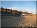
Holland-on-Sea: Cliff stabilisation works 2018 (1)
The area of Holland Cliff between Hazlemere Road and Kings Avenue is currently having stabilisation works carried out. A length of some 430 metres of cliff is being stabilised and here piles have been driven into the ground ready to accept sections of sheet metal piling. The work is planned to be finished by late spring 2019.
Image: © Nigel Cox
Taken: 27 Oct 2018
0.03 miles
2
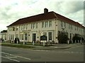
Kingscliff Hotel
This hotel stands along the seafront between Clacton-on-Sea and Holland-on-Sea.
Image: © Robert Edwards
Taken: 4 Oct 2006
0.05 miles
3
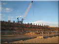
Holland-on-Sea: Cliff stabilisation works 2018 (2)
The area of Holland Cliff between Hazlemere Road and Kings Avenue is currently having stabilisation works carried out. A length of some 430 metres of cliff is being stabilised and here piles have been driven into the ground ready to accept sections of sheet metal piling. The work is planned to be finished by late spring 2019.
Image: © Nigel Cox
Taken: 27 Oct 2018
0.09 miles
4
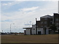
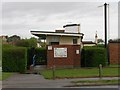
Toilets, Lyndhurst Road
This photograph shows public toilets on a small stretch of common ground facing the seafront at the western edge of Holland-on-Sea. Lyndhurst Road runs behind the toilet block, in front of the flats in the background.
Eastcliff Sports Ground and the footpath 'Sea Lane' (neither visible) are beyond the flats, while Hazlemere Road car park was behind me when taking the picture.
These toilets are indicated on some Ordnance Survey maps by "PC".
Image: © Duncan Graham
Taken: 30 Jul 2018
0.14 miles
6
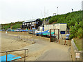
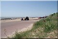
Gunfleet Sailing Club
Their slipway appears to be disappearing under accumulating sand.
Image: © Robin Webster
Taken: 30 Oct 2016
0.15 miles
7
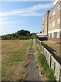
Footpath, Eastcliff Sports Ground - entrance
The photograph shows the footpath 'Sea Lane' to the east of Eastcliff Sports Ground. The footpath runs from Kings Parade (where the picture was taken, my back to the promenade and sea) to Holland Road. 'Sea Lane' intersects or is accessible from the end of Dulwich Road, Howard Road, Deanhill Avenue and Turpins Close. The footpath is 0.72 km long (according to a Tendring District Council estimate) and is currently slightly overgrown. It marks the boundary between Clacton-on-Sea and Holland-on-Sea.
Flats on Lyndhurst Road leading off the seafront are to right of picture.
Image: © Duncan Graham
Taken: 3 Jul 2018
0.17 miles
8
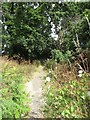
Footpath, Eastcliff Sports Ground
The photograph shows the footpath 'Sea Lane' to the east of Eastcliff Sports Ground.
See Image
Image: © Duncan Graham
Taken: 9 Jul 2018
0.18 miles
9
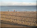
Clacton-on-Sea: Sea fishermen near Gunfleet Sailing Club
The Gunfleet Sands Wind Farm is visible on the horizon.
Image: © Nigel Cox
Taken: 27 Oct 2018
0.19 miles
10
Promenade and Purple Salsify
The flower on the coastal slope is Image
Image: © Glyn Baker
Taken: 20 May 2023
0.21 miles