IMAGES TAKEN NEAR TO
Nansen Road, CLACTON-ON-SEA, CO15 5EF
Introduction
This page details the photographs taken nearby to Nansen Road, CO15 5EF by members of the Geograph project.
The Geograph project started in 2005 with the aim of publishing, organising and preserving representative images for every square kilometre of Great Britain, Ireland and the Isle of Man.

There are currently over 7.5m images from over14,400 individuals and you can help contribute to the project by visiting https://www.geograph.org.uk
Image Map
Images are licensed for reuse under creativecommons.org/licenses/by-sa/2.0
Notes
- Clicking on the map will re-center to the selected point.
- The higher the marker number, the further away the image location is from the centre of the postcode.
Image Listing (7 Images Found)
Images are licensed for reuse under creativecommons.org/licenses/by-sa/2.0
Image
Details
Distance
1
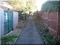
Holland-on-Sea: Footpath between Frinton Road and Slade Road
This footpath runs at the back of the houses between Frinton Road and Slade Road, and this is the view from the Slade Road end.
Old large scale Ordnance Survey maps show that a footpath and public right of way existed here long before there was any residential development.
Image: © Nigel Cox
Taken: 27 Oct 2018
0.06 miles
2

Picker's Ditch
Looking downstream from the Image
Image: © Glyn Baker
Taken: 20 May 2023
0.09 miles

4

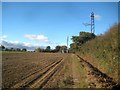
Holland-on-Sea: Farmland near Smythie's Farm
The farmland is criss-crossed by a series of high and low voltage electricity cables.
Image: © Nigel Cox
Taken: 27 Oct 2018
0.15 miles
5
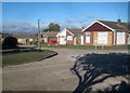
Holland-on-Sea: Fleetwood Close
Fleetwood Close is a cul-de-sac off Fleetwood Road.
Large scale Ordnance Survey maps show that this area was just fields in 1939, but by 1952 they show that the whole current estate, including these roads and houses, had been built.
The photographer is unsure whether the olive green post is a sewer vent, or a lamp post or both. At the bottom of the cul-de-sac is a standard lamp post.
Image: © Nigel Cox
Taken: 27 Oct 2018
0.16 miles
6
Holland-on-Sea: Footpath to Smythie's Farm
Old Victorian large scale Ordnance Survey maps show that this path existed long before the residential development of Holland-on-Sea commenced. The distant mobile phone mast is at the back of the farm.
Image: © Nigel Cox
Taken: 27 Oct 2018
0.17 miles
7

Shops and post office at junction of Stratford and Frinton Roads
The distinctive architecture of between the world wars
Image: © David Smith
Taken: 31 May 2017
0.23 miles