IMAGES TAKEN NEAR TO
Trafalgar Road, CLACTON-ON-SEA, CO15 1LR
Introduction
This page details the photographs taken nearby to Trafalgar Road, CO15 1LR by members of the Geograph project.
The Geograph project started in 2005 with the aim of publishing, organising and preserving representative images for every square kilometre of Great Britain, Ireland and the Isle of Man.

There are currently over 7.5m images from over14,400 individuals and you can help contribute to the project by visiting https://www.geograph.org.uk
Image Map
Images are licensed for reuse under creativecommons.org/licenses/by-sa/2.0
Notes
- Clicking on the map will re-center to the selected point.
- The higher the marker number, the further away the image location is from the centre of the postcode.
Image Listing (181 Images Found)
Images are licensed for reuse under creativecommons.org/licenses/by-sa/2.0
Image
Details
Distance
1
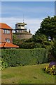
Martello Makeover
This Martello Tower is being used as a coastal watch station which was very much part of its original purpose
Image: © Glyn Baker
Taken: 27 Aug 2007
0.05 miles
2
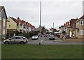
Nelson Road, Clacton-on-Sea
Residential street leading off seafront; photographed from promenade on Marine Parade West. Nelson Road leads from Marine Parade West to Freeland Road. This and neighbouring streets (Trafalgar Road, St Vincent Road, Collingwood Road) were named after Nelson, his victory and his associates.
Nelson Road is the last street running off the seafront when heading southwest to be entirely within the grid square TM 1714 on Ordnance Survey maps.
Image: © Duncan Graham
Taken: 31 Jan 2018
0.05 miles
3
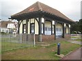
Clacton-on-Sea: Seafront shelter near Trafalgar Road
Clacton has a great number of seafront shelters, all of which are of different designs. This one is near the seaward end of Trafalgar Road.
Image: © Nigel Cox
Taken: 28 Oct 2018
0.08 miles
4
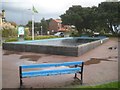
Clacton-on-Sea: Model Yacht Pond
This amenity is at the south-west end of the formal seafront gardens, and on the south-east side of Marine Parade West.
The first Ordnance Survey large scale map available online that shows such a pond here dates from 1939. This one and all subsequent ones available show a more elaborate feature with rounded ends rather than the simple rectangular shape of the present one.
A local council noticeboard nearby describes the amenity, somewhat bizarrely, as "favourable with young and old, residents and non residents"...
Image: © Nigel Cox
Taken: 28 Oct 2018
0.08 miles
5
St Vincent Road, Clacton-on-Sea
Residential street leading off seafront; photographed from promenade on Marine Parade West. St Vincent Road leads to the junction of Wash Lane, Kings Road and Freeland Road. Named after John Jervis, first Earl of St Vincent (1735 - 1823), First Lord of the Admiralty, who played a role in the defeat of Napoleon. This and neighbouring streets were named with Nelson associations: Nelson Road, Trafalgar Road, Collingwood Road.
On Ordnance Survey maps, St Vincent Road is at the western edge of grid square TM 1714 and just edges into TM 1614.
[Source of details on Earl of St Vincent: "Nelson: A Personal History" by Christopher Hibbert, 1994].
Image: © Duncan Graham
Taken: 31 Jan 2018
0.09 miles
6
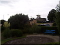
Martello Children's Zoo
Martello Children's Zoo at Clacton-on-Sea. Submitted to the BBC Domesday Reloaded project. http://www.bbc.co.uk/history/domesday/dblock/GB-616000-213000/picture/5
Image: © Martin Speck
Taken: 11 Oct 2011
0.10 miles
7
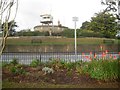
Martello tower
The base of the tower on Clacton sea front provides a base for a look-out station.
Image: © Trevor Harris
Taken: 27 May 2015
0.10 miles
8
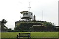
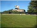
Clacton-on-Sea: Martello Tower F
The east coast Martello Towers were built between 1808 and 1812. 29 were built from St Osyth in Essex north-eastwards to Aldeburgh in Suffolk, and are named by Historic England in the same order from A to Z then AA to CC, so this is the sixth tower along. Just to confuse the issue the Ordnance Survey refer to this one as Tower No 6 on all their old mapping, but it's shown as No 8 on the latest OpenStreetMapping.
The east coast towers are not circular in plan nor oval as might be thought from this viewpoint, but more of a triangular ovoid for want of a better term.
This one is a Scheduled Monument and a Grade II Listed Building and the Historic England website describes it in particular (abridged) thus:-
"Martello Tower now a Coast Guard station. Vari-coloured brick, made at Grays, Essex. Stone parapet, rusticated stone dressings to 4 windows and a door at half height. Unlike the other Clacton Defence Towers this one had a moat, glacis and outer battery. The brick lined moat still survives, the wall being approximately 7 metres tall and the moat base 8 metres wide. Taking 4 years and built at a cost of approximately £5000 the situation was considered too unhealthy and the garrison was stationed at Weeley. Erosion by sea has claimed the battery."
As an aside the red hot pokers Kniphofia 'Nobilis' were flowering strongly along the seafront despite it being late October.
Image: © Nigel Cox
Taken: 28 Oct 2018
0.10 miles
9
Clacton-on-Sea: Martello Tower F
The east coast Martello Towers were built between 1808 and 1812. 29 were built from St Osyth in Essex north-eastwards to Aldeburgh in Suffolk, and are named by Historic England in the same order from A to Z then AA to CC, so this is the sixth tower along. Just to confuse the issue the Ordnance Survey refer to this one as Tower No 6 on all their old mapping, but it's shown as No 8 on the latest OpenStreetMapping.
The east coast towers are not circular in plan nor oval as might be thought from this viewpoint, but more of a triangular ovoid for want of a better term.
This one is a Scheduled Monument and a Grade II Listed Building and the Historic England website describes it in particular (abridged) thus:-
"Martello Tower now a Coast Guard station. Vari-coloured brick, made at Grays, Essex. Stone parapet, rusticated stone dressings to 4 windows and a door at half height. Unlike the other Clacton Defence Towers this one had a moat, glacis and outer battery. The brick lined moat still survives, the wall being approximately 7 metres tall and the moat base 8 metres wide. Taking 4 years and built at a cost of approximately £5000 the situation was considered too unhealthy and the garrison was stationed at Weeley. Erosion by sea has claimed the battery."
Image: © Nigel Cox
Taken: 17 Mar 2019
0.10 miles
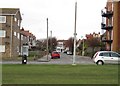
10
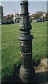
Lamp-post base on Marine Parade West
The photograph shows the ornamental base of a lamp-post standard on the promenade, Marine Parade West. Nelson Road recedes behind the lamp-post in the picture.
A red-brick block of flats now occupies the fenced-off space on the corner of Nelson Road visible in the background.
Most lamp-posts of this design, which formerly lined Clacton seafront, had their upper sections dismantled in 2014, including this one. (They had not worked for some years and Tendring District Council feared accidents caused by falling corroded metalwork).
Members of the United Kingdom Association of Street Lighting Enthusiasts suggest on their website www.ukastle.co.uk that these Clacton seafront lamp-posts were probably late Victorian in date and certainly made by the firm Johnson and Phillips.
See Image
Image: © Duncan Graham
Taken: 9 Apr 2005
0.10 miles