IMAGES TAKEN NEAR TO
Queens Road, CLACTON-ON-SEA, CO15 1AD
Introduction
This page details the photographs taken nearby to Queens Road, CO15 1AD by members of the Geograph project.
The Geograph project started in 2005 with the aim of publishing, organising and preserving representative images for every square kilometre of Great Britain, Ireland and the Isle of Man.

There are currently over 7.5m images from over14,400 individuals and you can help contribute to the project by visiting https://www.geograph.org.uk
Image Map
Images are licensed for reuse under creativecommons.org/licenses/by-sa/2.0
Notes
- Clicking on the map will re-center to the selected point.
- The higher the marker number, the further away the image location is from the centre of the postcode.
Image Listing (8 Images Found)
Images are licensed for reuse under creativecommons.org/licenses/by-sa/2.0
Image
Details
Distance
1
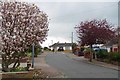
Magnolia in Prince Philip Ave
All the streets round here are named after members of the Royal Family.
Image: © Glyn Baker
Taken: 3 Apr 2019
0.06 miles

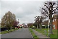
3
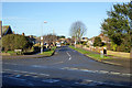
Queens Road, Clacton
Looking from West Road.
Image: © Robin Webster
Taken: 30 Nov 2018
0.08 miles
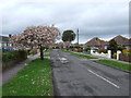
6
King's Road Clacton
Many of the streets round here have a Royal theme.
Image: © Glyn Baker
Taken: 3 Apr 2019
0.17 miles
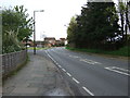
7

Clacton-on-Sea: Alton Park Lane
There was once a farmstead called Altonpark in this vicinity, that was accessed by a track off Jaywick Lane. By the time that the 1964 Ordnance Survey large scale map was issued the lane, according to the OS, extended all the way from Jaywick Lane to Leas Road and Cherry Tree Avenue in Clacton-on-Sea, as seen in this view. It is now a public footpath.
Image: © Nigel Cox
Taken: 28 Oct 2018
0.18 miles
8

Footpath 167_15 to Jawick Lane
This footpath links Cherry Tree Ave and Jawick Lane via the Airfield
Image: © Glyn Baker
Taken: 3 Apr 2019
0.20 miles