IMAGES TAKEN NEAR TO
Naze Park Road, WALTON ON THE NAZE, CO14 8JN
Introduction
This page details the photographs taken nearby to Naze Park Road, CO14 8JN by members of the Geograph project.
The Geograph project started in 2005 with the aim of publishing, organising and preserving representative images for every square kilometre of Great Britain, Ireland and the Isle of Man.

There are currently over 7.5m images from over14,400 individuals and you can help contribute to the project by visiting https://www.geograph.org.uk
Image Map
Images are licensed for reuse under creativecommons.org/licenses/by-sa/2.0
Notes
- Clicking on the map will re-center to the selected point.
- The higher the marker number, the further away the image location is from the centre of the postcode.
Image Listing (50 Images Found)
Images are licensed for reuse under creativecommons.org/licenses/by-sa/2.0
Image
Details
Distance
1
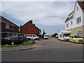
High Tree Lane
The view off Naze Park Road in Walton on the Naze.
Image: © Gordon Griffiths
Taken: 24 Jul 2019
0.04 miles
2
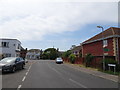
Hall Lane
The view at Walton-on-the-Naze.
Image: © Gordon Griffiths
Taken: 24 Jul 2019
0.08 miles
3
First Avenue, Walton-on-the-Naze
Looking north west.
Image: © JThomas
Taken: 26 Apr 2017
0.09 miles
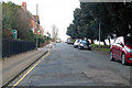
4
Naze Park Road
The view in Walton-on-the-Naze.
Image: © Gordon Griffiths
Taken: 24 Jul 2019
0.09 miles
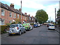
5
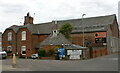
Former foundry, Hall Lane, Walton-on-the-Naze
The foundry was established in 1875 by Robert Warner whose father John in 1836 built East Terrace, a superior residential development nearby. The road on the left leads into an industrial estate.
Image: © David Kemp
Taken: 25 Sep 2022
0.10 miles
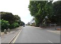
6
Naze Park Road, Walton-on-the-Naze
Towards the Naze.
Image: © Robin Webster
Taken: 9 Feb 2019
0.10 miles
7
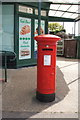
George VI postbox on Hall Lane, Walton on the Naze
Postbox No. CO14 6.
See Image] for context.
Image: © JThomas
Taken: 26 Apr 2017
0.12 miles
8
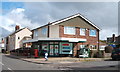
Naze Park Stores
On Hall Lane, Walton on the Naze.
Showing position of Postbox No. CO14 6.
See Image for postbox.
Image: © JThomas
Taken: 26 Apr 2017
0.12 miles
9
Walton-on-the-Naze: Walton Baptist Church
The Church is on Hall Lane at its junction with Beatrice Road. It appears on the Ordnance Survey map of 1925 as a Mission Hall. The cottages beyond might have originally been built for workers in Warner's iron foundry just up the road.
Image: © Nigel Cox
Taken: 30 Aug 2009
0.14 miles
10
Residential properties in Naze Park Road, Walton-on-the-Naze
Image: © David Kemp
Taken: 25 Sep 2022
0.15 miles