IMAGES TAKEN NEAR TO
Seaview Heights, WALTON ON THE NAZE, CO14 8ET
Introduction
This page details the photographs taken nearby to Seaview Heights, CO14 8ET by members of the Geograph project.
The Geograph project started in 2005 with the aim of publishing, organising and preserving representative images for every square kilometre of Great Britain, Ireland and the Isle of Man.

There are currently over 7.5m images from over14,400 individuals and you can help contribute to the project by visiting https://www.geograph.org.uk
Image Map
Images are licensed for reuse under creativecommons.org/licenses/by-sa/2.0
Notes
- Clicking on the map will re-center to the selected point.
- The higher the marker number, the further away the image location is from the centre of the postcode.
Image Listing (142 Images Found)
Images are licensed for reuse under creativecommons.org/licenses/by-sa/2.0
Image
Details
Distance
1
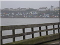
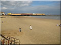
Walton on the Naze: beach hut view from pier
From Britain's second longest pleasure pier (Southend's being the longer one), we look across the water to the rows of beach huts which line the steep face behind the prom. The tide is fully in at the moment, meaning that there is no sand to be seen - but it would start receding shortly.
Image: © Chris Downer
Taken: 12 Nov 2011
0.05 miles
2
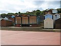
Walton-on-the-Naze: Seafront shelter
This functional concrete shelter nestles in the massed ranks of beach huts at the foot of Walton's shallow cliffs. One very useful feature of Walton's sea front is that each facility, such as a lifebelt or a public convenience, has a notice giving the distance in each direction along the front to the next facility of its kind.
Image: © Nigel Cox
Taken: 30 Aug 2009
0.06 miles
3
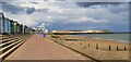
Walton Promenade
Looking towards the pier
Image: © Glyn Baker
Taken: 20 May 2023
0.07 miles
5
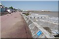
Walton-on-the-Naze: The beach and Walton Pier
Walton's fine sandy beach looking surprisingly deserted on a Sunday during the August Bank Holiday weekend.
Image: © Nigel Cox
Taken: 30 Aug 2009
0.08 miles
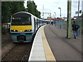
6

Walton-on-the-Naze station, with National Express (East Anglia) train from Liverpool Street
View eastward, towards the buffer-stops: ex-GER terminus of line from (London) - Colchester via Thorpe-le-Soken.
Image: © Ben Brooksbank
Taken: 20 Sep 2008
0.08 miles
7
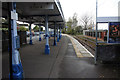
Walton on the Naze station
Just a basic one platform railway now.
Image: © roger geach
Taken: 31 Oct 2012
0.08 miles
8
Walton-on-the-Naze Railway Station
The end of the line. A vital link which enables visitors to get here from London.
Image: © Robin Lucas
Taken: 8 May 2008
0.08 miles
9
Walton-on-the-Naze railway station
Opened in 1867 by the Great Eastern Railway as the terminus of its line from Colchester. View east towards the buffer stops. The original GER station building is still extant but no longer in railway use. At the end of the (slightly shortened) platform now is a more 'functional' structure.
Image: © Nigel Thompson
Taken: 14 Jul 2007
0.08 miles
10
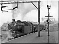
Walton-on-the-Naze Station with steam train during the period of local electrification
View eastward, towards the buffer-stops; terminus of ex-GE branch from Thorpe-le-Soken on the Colchester - Clacton-on-Sea line. The lines from Colchester had been electrified in isolation from 16/3/1959, but electric services from London did not begin until 18/6/1962 and were not fully operational until January 1963. This steam train in March 1960 was the 12.47 to Liverpool Street, headed by N7/5 0-6-2T No. 69651.
Image: © Ben Brooksbank
Taken: 26 Mar 1960
0.09 miles