IMAGES TAKEN NEAR TO
CO13 0GW
Introduction
This page details the photographs taken nearby to CO13 0GW by members of the Geograph project.
The Geograph project started in 2005 with the aim of publishing, organising and preserving representative images for every square kilometre of Great Britain, Ireland and the Isle of Man.

There are currently over 7.5m images from over14,400 individuals and you can help contribute to the project by visiting https://www.geograph.org.uk
Image Map
Images are licensed for reuse under creativecommons.org/licenses/by-sa/2.0
Notes
- Clicking on the map will re-center to the selected point.
- The higher the marker number, the further away the image location is from the centre of the postcode.
Image Listing (6 Images Found)
Images are licensed for reuse under creativecommons.org/licenses/by-sa/2.0
Image
Details
Distance
2
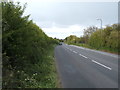
B1034 towards Kirby-le-Soken
Looking north east.
Image: © JThomas
Taken: 26 Apr 2017
0.04 miles
3
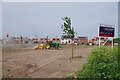
Samphire Meadows
Humm..... with a name like that it might be fun trying to get flood insurance! Just one of what appear to be dozens of building sites all over Tendering.
Image: © Glyn Baker
Taken: 19 May 2023
0.11 miles
5
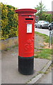
George V postbox on Kirby Road, Walton on the Naze
Postbox No. CO14 118.
See Image] for context.
Image: © JThomas
Taken: 26 Apr 2017
0.23 miles
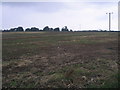
6
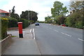
Kirby Road, Walton on the Naze
Showing position of Postbox No. CO14 118.
See Image] for postbox.
Image: © JThomas
Taken: 26 Apr 2017
0.23 miles