IMAGES TAKEN NEAR TO
Winnock Road, COLCHESTER, CO1 2FL
Introduction
This page details the photographs taken nearby to Winnock Road, CO1 2FL by members of the Geograph project.
The Geograph project started in 2005 with the aim of publishing, organising and preserving representative images for every square kilometre of Great Britain, Ireland and the Isle of Man.

There are currently over 7.5m images from over14,400 individuals and you can help contribute to the project by visiting https://www.geograph.org.uk
Image Map (Loading...)


Getting Data...Please wait
Leaflet Map data © OpenStreetMap
Images are licensed for reuse under creativecommons.org/licenses/by-sa/2.0
Notes
- Clicking on the map will re-center to the selected point.
- The higher the marker number, the further away the image location is from the centre of the postcode.
Image Listing (87 Images Found)
Images are licensed for reuse under creativecommons.org/licenses/by-sa/2.0
Image
Details
Distance
1
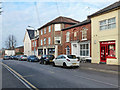
Businesses on Military Road, Colchester
Take away food, cash registers, a tanning salon and women's fashions. The tanning salon is the one with arched windows, and is dated 1863.
Image: © Robin Webster
Taken: 17 Jan 2016
0.03 miles
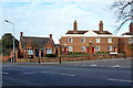
3
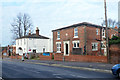
24 and 26 Military Road, Colchester
Not nationally listed probably mid 19th century buildings, the nearer has on a stone 'Ivy Lodge', but no date.
Image: © Robin Webster
Taken: 17 Jan 2016
0.06 miles
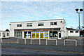
4
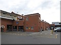
Aldi supermarket, Colchester
The store is set back from Magdalen Street, with its own small car park, behind a row of townhouses which front the street
Image: © David Smith
Taken: 31 May 2017
0.07 miles
5
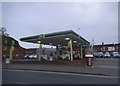
BP garage on Magdalen Street, Colchester
Image: © David Howard
Taken: 4 Apr 2017
0.08 miles
6
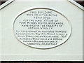
Kendall Almshouses, Colchester - inscription
For the building, see Image
Image: © Robin Webster
Taken: 17 Jan 2016
0.09 miles
7
Kendall Almshouses, Colchester
Two identical large blocks, one and a part of the other visible here, and several smaller houses typified by the building on the left. The large blocks are grade II listed buildings, dated 1791 and 1803 for the one to the right. A detail of the inscription on the pediment for the 1791 building is here Image Rather oddly, the name of the Almshouses (at least for this block) does not correspond to the stated benefactor, Arthur Winsley. However, on older maps, before the smaller houses were built, the two big blocks are indeed called Winsley's Almshouses.
Image: © Robin Webster
Taken: 17 Jan 2016
0.09 miles
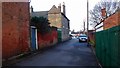
9
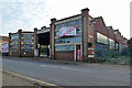
Disused bus garage, Magdalen Street, Colchester
Judging by the sign, soon to be seen no more.
Image: © Robin Webster
Taken: 17 Jan 2016
0.10 miles
10
Vacant car dealer's premises, Military Road, Colchester
Formerly Lookers, dealing in Renault cars. They still have other Colchester sites, but not for Renaults.
Image: © Robin Webster
Taken: 17 Jan 2016
0.11 miles