IMAGES TAKEN NEAR TO
Burr Close, HARWICH, CO12 5EN
Introduction
This page details the photographs taken nearby to Burr Close, CO12 5EN by members of the Geograph project.
The Geograph project started in 2005 with the aim of publishing, organising and preserving representative images for every square kilometre of Great Britain, Ireland and the Isle of Man.

There are currently over 7.5m images from over14,400 individuals and you can help contribute to the project by visiting https://www.geograph.org.uk
Image Map (Loading...)


Getting Data...Please wait
Leaflet Map data © OpenStreetMap
Images are licensed for reuse under creativecommons.org/licenses/by-sa/2.0
Notes
- Clicking on the map will re-center to the selected point.
- The higher the marker number, the further away the image location is from the centre of the postcode.
Image Listing (14 Images Found)
Images are licensed for reuse under creativecommons.org/licenses/by-sa/2.0
Image
Details
Distance
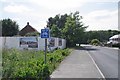
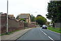
3
Oakley Road (B1414), Dovercourt
Looking north east.
Image: © JThomas
Taken: 26 Apr 2017
0.20 miles
4
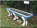
Six Legged Horse Trough
Old horse trough with its legs in the shape of horses hooves near to Ramsey, Essex. For other views see http://www.geograph.org.uk/photo/1724303 http://www.geograph.org.uk/photo/1724299
Image: © Keith Evans
Taken: 18 Feb 2010
0.21 miles
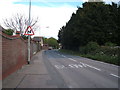
5
B1414 Oakley Road
Heading towards Dovercourt and Harwich.
Image: © Robin Webster
Taken: 8 Sep 2018
0.22 miles
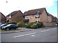
6
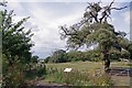
St Michel's Parkland
A public open space once the Park of Michelstowe Hall a medieval Manor demolished in the nineteenth century see the Image
Image: © Glyn Baker
Taken: 3 Jul 2020
0.22 miles
7
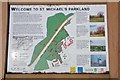
Interpretation Board
The information board about Image
Image: © Glyn Baker
Taken: 3 Jul 2020
0.22 miles
8
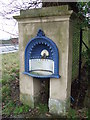
Drinking Fountain
Drinking fountain near to Ramsey, Essex for other views see http://www.geograph.org.uk/photo/1724303 http://www.geograph.org.uk/photo/1724295
Image: © Keith Evans
Taken: 18 Feb 2010
0.22 miles
9
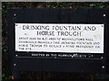
Information Plaque
Information plaque near to Ramsey, Essex For view of the drinking fountain see http://www.geograph.org.uk/photo/1724299 and the horse trough http://www.geograph.org.uk/photo/1724295
Image: © Keith Evans
Taken: 18 Feb 2010
0.22 miles
10
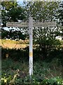
Direction Sign ? Signpost on the B1352 in Ramsey
Located in Ramsey on the southwest side of the T junction of the B1352 Church Hill and Mayes Lane in Ramsey and Parkeston parish. 3 arms and pyramid finial.
Milestone Society National ID: EX_TM2130
Image: © V Lungley
Taken: 1 Apr 2021
0.23 miles