IMAGES TAKEN NEAR TO
High Street, HARWICH, CO12 3AU
Introduction
This page details the photographs taken nearby to High Street, CO12 3AU by members of the Geograph project.
The Geograph project started in 2005 with the aim of publishing, organising and preserving representative images for every square kilometre of Great Britain, Ireland and the Isle of Man.

There are currently over 7.5m images from over14,400 individuals and you can help contribute to the project by visiting https://www.geograph.org.uk
Image Map
Images are licensed for reuse under creativecommons.org/licenses/by-sa/2.0
Notes
- Clicking on the map will re-center to the selected point.
- The higher the marker number, the further away the image location is from the centre of the postcode.
Image Listing (132 Images Found)
Images are licensed for reuse under creativecommons.org/licenses/by-sa/2.0
Image
Details
Distance
1
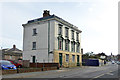
Harrison House, Main Road, Dovercourt
A mid 19th century grade II listed building. The listing describes it as 'Shops with flats' and makes no mention of the areas and basement level, instead describing 'projecting flat-roofed shops'. These have evidently been removed and the basement exposed. It looks very convincing - is this a reversion to the original state?
Image: © Robin Webster
Taken: 8 Sep 2018
0.00 miles
3
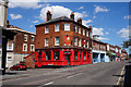
Kings Arms, High Street, Dovercourt
http://www.geograph.org.uk/photo/5894259
Image: © Ian S
Taken: 28 Jul 2018
0.02 miles
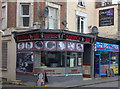
7
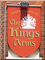
Kings Arms, High Street, Dovercourt
http://www.geograph.org.uk/photo/5894256
Image: © Ian S
Taken: 28 Jul 2018
0.02 miles
8
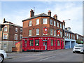
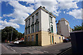
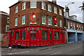
The Kings Arms, Dovercourt
Featuring live music on the first and last Sunday of the month.
Image: © Robin Webster
Taken: 8 Sep 2018
0.02 miles
9
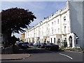
Orwell Road, Dovercourt
Orwell Road has more the look of a street in the Bayswater area of London than somewhere on the Essex Coast. It would have been built sometime in the 1850s at a time when Dovercourt was being promoted as a new resort.
During World War One, at No. 9 Orwell Road, Dovercourt (within this terrace), there was a Home Hospital - The Women’s Suffrage [Field] Hospital. The ‘Men’s Society for Women’s Rights’ organised it in August 1914. It may not have operated beyond 1916, because it is reported that the Society “seems not to have been active” after that year – however, the staff may have carried on regardless. Today, the terrace is Grade II listed.
https://greatwarhomehospitals.wordpress.com/
Image: © David Kemp
Taken: 11 Aug 2007
0.03 miles
10
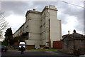
Orwell Road terrace
The rear of this terrace overlooking the park
Image: © Robert Eva
Taken: 27 Apr 2017
0.03 miles