IMAGES TAKEN NEAR TO
Green Lane, MANNINGTREE, CO11 2NL
Introduction
This page details the photographs taken nearby to Green Lane, CO11 2NL by members of the Geograph project.
The Geograph project started in 2005 with the aim of publishing, organising and preserving representative images for every square kilometre of Great Britain, Ireland and the Isle of Man.

There are currently over 7.5m images from over14,400 individuals and you can help contribute to the project by visiting https://www.geograph.org.uk
Image Map
Images are licensed for reuse under creativecommons.org/licenses/by-sa/2.0
Notes
- Clicking on the map will re-center to the selected point.
- The higher the marker number, the further away the image location is from the centre of the postcode.
Image Listing (8 Images Found)
Images are licensed for reuse under creativecommons.org/licenses/by-sa/2.0
Image
Details
Distance
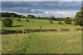
1
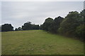
View across to Dairy House, south of Mistley
Having missed the turning of the Essex Way, which turns right in the middle distance. Dairy House farm and cottages are listed Grade II, circa 1777 https://historicengland.org.uk/listing/the-list/list-entry/1260993.
Image: © Tim Heaton
Taken: 16 Oct 2020
0.04 miles
3
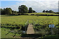
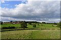
Footbridge, but not the Essex Way
We missed the turning that takes the Essex Way long distance footpath into Furze Hill Woods - ending up at this footbridge.
Image: © Chris Heaton
Taken: 16 Oct 2020
0.13 miles
4
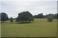
Footpath from Beech Plantation heading for Mistley
Image: © Chris Heaton
Taken: 16 Oct 2020
0.20 miles

6
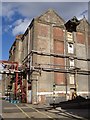
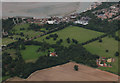
Footpath through factory site
The old maltings at Mistley are still working although some similar buildings have already been converted into luxury flats overlooking the River Stour. The two yellow lines in the foreground mark out the route of the Essex Way, an 81 mile footpath across the county from Epping to Harwich. Here it passes right through the factory complex in Mistley.
Image: © David Williams
Taken: 7 Oct 2006
0.21 miles