IMAGES TAKEN NEAR TO
Chester Grove, MANNINGTREE, CO11 2FA
Introduction
This page details the photographs taken nearby to Chester Grove, CO11 2FA by members of the Geograph project.
The Geograph project started in 2005 with the aim of publishing, organising and preserving representative images for every square kilometre of Great Britain, Ireland and the Isle of Man.

There are currently over 7.5m images from over14,400 individuals and you can help contribute to the project by visiting https://www.geograph.org.uk
Image Map
Images are licensed for reuse under creativecommons.org/licenses/by-sa/2.0
Notes
- Clicking on the map will re-center to the selected point.
- The higher the marker number, the further away the image location is from the centre of the postcode.
Image Listing (18 Images Found)
Images are licensed for reuse under creativecommons.org/licenses/by-sa/2.0
Image
Details
Distance
4
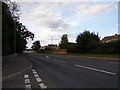
A137 Cox's Hill, Lawford
At the junction with Lawford Place
Image: © Geographer
Taken: 17 Aug 2018
0.18 miles
5
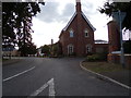
Lawford Place, Lawford
At the junction with the A137 Cox's Hill
Image: © Geographer
Taken: 17 Aug 2018
0.18 miles
6
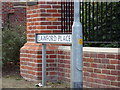
Lawford Place sign
On Lawford Place at the junction with the A137 Cox's Hill
Image: © Geographer
Taken: 17 Aug 2018
0.18 miles
7
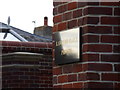
Lawford Place sign
On Lawford Place at the junction with the A137 Cox's Hill
Image: © Geographer
Taken: 17 Aug 2018
0.18 miles
8
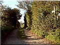
Public Footpath on Cox's Hill, Lawford, Essex
This footpath takes you down to Lawford parish church and beyond.
Image: © Robert Edwards
Taken: 6 Nov 2006
0.18 miles
9
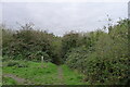
Entering Owl's Flight Dell, Lawford
The Essex Way entering Lawford through a small Conservation Area.
Image: © Tim Heaton
Taken: 16 Oct 2020
0.19 miles