IMAGES TAKEN NEAR TO
Bergholt Road, MANNINGTREE, CO11 1QZ
Introduction
This page details the photographs taken nearby to Bergholt Road, CO11 1QZ by members of the Geograph project.
The Geograph project started in 2005 with the aim of publishing, organising and preserving representative images for every square kilometre of Great Britain, Ireland and the Isle of Man.

There are currently over 7.5m images from over14,400 individuals and you can help contribute to the project by visiting https://www.geograph.org.uk
Image Map (10 Images)


Getting Data...Please wait
Leaflet Map data © OpenStreetMap
Images are licensed for reuse under creativecommons.org/licenses/by-sa/2.0
Notes
- Clicking on the map will re-center to the selected point.
- The higher the marker number, the further away the image location is from the centre of the postcode.
Image Listing (10 Images Found)
Images are licensed for reuse under creativecommons.org/licenses/by-sa/2.0
Image
Details
Distance
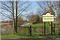
1
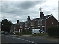
Houses on Bergholt Road, Cattawade
The footpath sign points to the Stour Valley Path which runs along the road past the houses and then crosses fields to Flatford
Image: © David Smith
Taken: 16 Jun 2014
0.01 miles
2
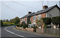
Rowland Villas and Victor Villas
Houses dated 1896 beside the B1070. I believe that the road is still Bergholt Road at this point and probably becomes Manningtree Road just around the corner!
Image: © Martin Addison
Taken: 17 Apr 2014
0.01 miles
4
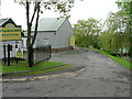
Entrance to Brantham Mill Industrial Estate
Image: © JThomas
Taken: 10 May 2012
0.07 miles
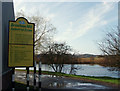
5
Canalised Stour by Brantham Mill
The River Stour Navigation at Brantham runs parallel to the upper tidal reaches of the river and was constructed in the 18th century to allow the river to be navigable at all stages of the tide. The canalised stretch runs from Cattawade to Flatford Mill
Image: © Liz McCabe
Taken: 9 Mar 2007
0.07 miles

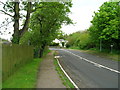
7
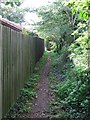
Footpath
Footpath near to Cattawade, Suffolk.
Image: © Keith Evans
Taken: 17 Oct 2013
0.08 miles
8
Brantham Mill Industrial estate
A rural industrial estate on the banks of the canalised River Stour
Image: © Liz McCabe
Taken: 9 Mar 2007
0.09 miles
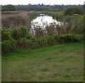
9
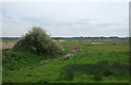
Field Beside The Stour
It is apparent that this field is lower than the level of the river which explains why it is poorly drained. It is popular with birds though - Redshank, Lapwing, Heron, Carrion Crow and our first Swallows of the year were noted as we strolled by. No doubt there were others that escaped notice!
Image: © Martin Addison
Taken: 17 Apr 2014
0.24 miles
10
River Stour from the Stour Valley Walk
Image: © Christopher Hilton
Taken: 24 Sep 2022
0.24 miles