IMAGES TAKEN NEAR TO
Barn Lane, SUDBURY, CO10 9NB
Introduction
This page details the photographs taken nearby to Barn Lane, CO10 9NB by members of the Geograph project.
The Geograph project started in 2005 with the aim of publishing, organising and preserving representative images for every square kilometre of Great Britain, Ireland and the Isle of Man.

There are currently over 7.5m images from over14,400 individuals and you can help contribute to the project by visiting https://www.geograph.org.uk
Image Map
Images are licensed for reuse under creativecommons.org/licenses/by-sa/2.0
Notes
- Clicking on the map will re-center to the selected point.
- The higher the marker number, the further away the image location is from the centre of the postcode.
Image Listing (7 Images Found)
Images are licensed for reuse under creativecommons.org/licenses/by-sa/2.0
Image
Details
Distance
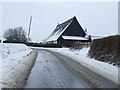
1
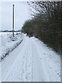
Country Lane
Snow covered country lane near to Preston St.Mary, Suffolk.
Image: © Keith Evans
Taken: 21 Dec 2010
0.07 miles
2
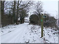
Restricted Byway
Minor road and restricted byway sign near to Preston St.Mary, Suffolk.
Image: © Keith Evans
Taken: 21 Dec 2010
0.13 miles
3
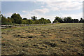
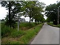
Hay field near Down Hall
Viewed from the footpath immediately south of Down Hall, this grass field has recently been cut for hay. A minor road to Preston St Mary follows the far side of the fence.
Image: © Bob Jones
Taken: 18 Aug 2009
0.13 miles
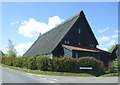
5
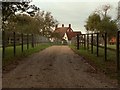
Converted Barn
Converted barn at Mortimer's Farm near to Preston St.Mary, Suffolk.
Image: © Keith Evans
Taken: 21 Dec 2010
0.20 miles