IMAGES TAKEN NEAR TO
Preston St. Mary, SUDBURY, CO10 9LT
Introduction
This page details the photographs taken nearby to CO10 9LT by members of the Geograph project.
The Geograph project started in 2005 with the aim of publishing, organising and preserving representative images for every square kilometre of Great Britain, Ireland and the Isle of Man.

There are currently over 7.5m images from over14,400 individuals and you can help contribute to the project by visiting https://www.geograph.org.uk
Image Map (Loading...)


Getting Data...Please wait
Leaflet Map data © OpenStreetMap
Images are licensed for reuse under creativecommons.org/licenses/by-sa/2.0
Notes
- Clicking on the map will re-center to the selected point.
- The higher the marker number, the further away the image location is from the centre of the postcode.
Image Listing (7 Images Found)
Images are licensed for reuse under creativecommons.org/licenses/by-sa/2.0
Image
Details
Distance
1
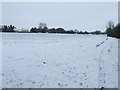
Footpath And Field Boundary
Looking south west along the snow covered footpath and field boundary near to Preston St.Mary, Suffolk.
Image: © Keith Evans
Taken: 21 Dec 2010
0.11 miles
2
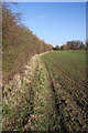
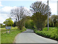
Footpath to Rookwood Lane
This path follows the northern edge of a large field. It leads to Rookwood Lane, with an alternative route which heads to Preston St Mary.
Image: © Bob Jones
Taken: 10 Dec 2009
0.13 miles
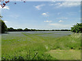
3
By the lane to Preston St Mary
Looking north from the lane into a field 1km west of the village.
Image: © Andrew Hill
Taken: 28 Nov 2009
0.15 miles
4
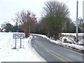
Entering Preston St.Mary
Entering Preston St.Mary, Suffolk.
Image: © Keith Evans
Taken: 21 Dec 2010
0.15 miles
5
Entering Preston St. Mary
Some way to go to the main concentration of houses, yet the parish boundary has already been passed. A sort of compromise position for the sign.
Image: © Robin Webster
Taken: 17 Apr 2017
0.16 miles
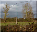
6
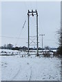
Snow Covered Pylons
Snow covered pylons near to Preston St.Mary, Suffolk.
Image: © Keith Evans
Taken: 21 Dec 2010
0.17 miles