IMAGES TAKEN NEAR TO
Rodbridge Corner/Mills Lane, Rodbridge Corner, SUDBURY, CO10 9HJ
Introduction
This page details the photographs taken nearby to Rodbridge Corner/Mills Lane, Rodbridge Corner, CO10 9HJ by members of the Geograph project.
The Geograph project started in 2005 with the aim of publishing, organising and preserving representative images for every square kilometre of Great Britain, Ireland and the Isle of Man.

There are currently over 7.5m images from over14,400 individuals and you can help contribute to the project by visiting https://www.geograph.org.uk
Image Map
Images are licensed for reuse under creativecommons.org/licenses/by-sa/2.0
Notes
- Clicking on the map will re-center to the selected point.
- The higher the marker number, the further away the image location is from the centre of the postcode.
Image Listing (48 Images Found)
Images are licensed for reuse under creativecommons.org/licenses/by-sa/2.0
Image
Details
Distance
2
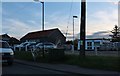
Beer barrels outside Nethergate Brewery
Image: © David Howard
Taken: 14 Mar 2019
0.05 miles
3
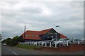
Nethergate Brewery, Rodbridge Corner
The black building in the middle was only built around a year ago. It is also open to the public to buy their beer directly. https://www.nethergate.co.uk/index.html
Image: © David Howard
Taken: 14 Mar 2019
0.06 miles
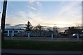
4
Rodbridge Corner south of Long Melford
Image: © Adrian S Pye
Taken: 28 Aug 2015
0.07 miles
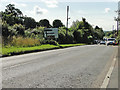
5
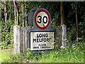
Long Melford Village Name sign
On the B1064 Sudbury Road at Rodbridge Corner
Image: © Geographer
Taken: 22 May 2014
0.07 miles
6
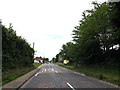
Part of the B1064 as it approaches Rodbridge Hill
Image: © Robert Edwards
Taken: 1 Jul 2009
0.08 miles
7
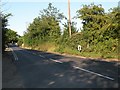
Entering Long Melford on the B1064 Sudbury Road
At Rodbridge Corner
Image: © Geographer
Taken: 22 May 2014
0.11 miles
8
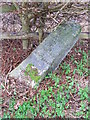
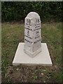
Old Milestone
Old milestone on what was the A134 at Long Melford, Suffolk. For overall view see http://www.geograph.org.uk/photo/2281737
30 May 2013 Since this photo was taken the stone has now been restored see http://www.geograph.org.uk/photo/3508668 http://www.geograph.org.uk/photo/3508674
Image: © Keith Evans
Taken: 23 Feb 2011
0.12 miles
9
Old Milestone
Restored old milestone on what was the A134 at Long Melford, Suffolk. For overall view see http://www.geograph.org.uk/photo/3508674 and for views before restoration http://www.geograph.org.uk/photo/2281743 http://www.geograph.org.uk/photo/2281737 For info on the restoration see http://www.eadt.co.uk/news/long_melford_heritage_enthusiasts_aim_to_restore_neglected_milestone_to_former_glory_1_2022410
Image: © Keith Evans
Taken: 30 May 2013
0.12 miles
10
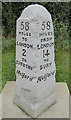
Old Milestone by the A1064, Rodbridge Corner, Long Melford Parish
Carved stone post by the A1064 (was A134), in parish of LONG MELFORD (BABERGH District), Rodbridge Corner, North of bus shelter and opposite Ropers Lane junction on wide verge, on East side of road. Sudbury pillar, erected by the Sudbury to Bury St Edmunds turnpike trust in the 19th century.
Inscription reads:-
: 58 / MILES / TO / LONDON / 2 / TO / SUDBURY / Melford : : 58 / MILES / FROM / LONDON / 14 / TO / BURY / Melford :
Carved benchmark and rivet on top.
Milestone Society National ID: SU_SBBU02.
Image: © Mike Bardell
Taken: 21 Oct 2015
0.14 miles