Old Milestone by the A1064, Rodbridge Corner, Long Melford Parish
Introduction
The photograph on this page of Old Milestone by the A1064, Rodbridge Corner, Long Melford Parish by Mike Bardell as part of the Geograph project.
The Geograph project started in 2005 with the aim of publishing, organising and preserving representative images for every square kilometre of Great Britain, Ireland and the Isle of Man.

There are currently over 7.5m images from over 14,400 individuals and you can help contribute to the project by visiting https://www.geograph.org.uk
Old Milestone by the A1064, Rodbridge Corner, Long Melford Parish
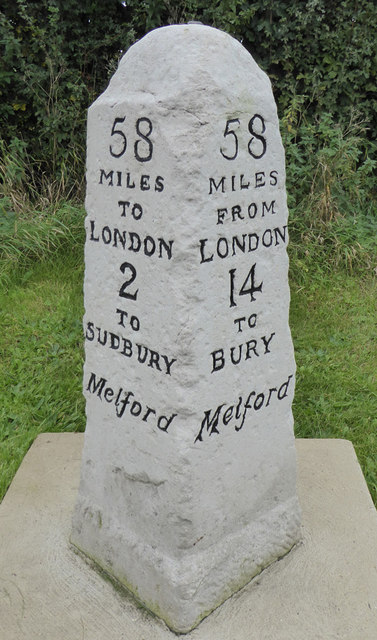
Image: © Mike Bardell Taken: 21 Oct 2015
Carved stone post by the A1064 (was A134), in parish of LONG MELFORD (BABERGH District), Rodbridge Corner, North of bus shelter and opposite Ropers Lane junction on wide verge, on East side of road. Sudbury pillar, erected by the Sudbury to Bury St Edmunds turnpike trust in the 19th century. Inscription reads:- : 58 / MILES / TO / LONDON / 2 / TO / SUDBURY / Melford : : 58 / MILES / FROM / LONDON / 14 / TO / BURY / Melford : Carved benchmark and rivet on top. Milestone Society National ID: SU_SBBU02.
Images are licensed for reuse under creativecommons.org/licenses/by-sa/2.0
Image Location
Latitude
52.063394
Longitude
0.710795