IMAGES TAKEN NEAR TO
The Street, SUDBURY, CO10 8RA
Introduction
This page details the photographs taken nearby to The Street, CO10 8RA by members of the Geograph project.
The Geograph project started in 2005 with the aim of publishing, organising and preserving representative images for every square kilometre of Great Britain, Ireland and the Isle of Man.

There are currently over 7.5m images from over14,400 individuals and you can help contribute to the project by visiting https://www.geograph.org.uk
Image Map
Images are licensed for reuse under creativecommons.org/licenses/by-sa/2.0
Notes
- Clicking on the map will re-center to the selected point.
- The higher the marker number, the further away the image location is from the centre of the postcode.
Image Listing (28 Images Found)
Images are licensed for reuse under creativecommons.org/licenses/by-sa/2.0
Image
Details
Distance
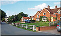
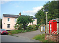
1
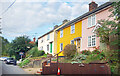
Colourful Houses, Poslingford
Having a colourful exterior on your house is quite usual in this area.
Much more so than where we live in Oxfordshire.
Image: © Des Blenkinsopp
Taken: 16 Sep 2021
0.03 miles
3
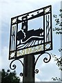
Poslingford village sign
Poslingford village sign, Poslingford, Suffolk.
Image: © Keith Evans
Taken: 5 Jun 2008
0.04 miles
4
Poslingford village sign
At the top border of the sign is a heavy horse in the pasture representing the importance of the horse before the tractor and mechanisation. On each side are straws of golden wheat symbolic of the arable farming. In the centre panel is the church of St Mary with the trees, just as they are in the churchyard. The tributary of the Chilton Stream is no longer a ford but is represented by the wavy line between the church and the ploughed field in the foreground. The gold ring in each corner, relates to the Poslingford ring, found by a resident in the village while gardening in 1955. It was found to be from the 9th century and is in the British Museum.
https://www.geograph.org.uk/photo/6771676
Image: © Adrian S Pye
Taken: 15 Oct 2008
0.05 miles
5
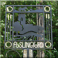
Poslingford village sign (detail)
At the top border of the sign is a heavy horse in the pasture representing the importance of the horse before the tractor and mechanisation. On each side are straws of golden wheat symbolic of the arable farming. In the centre panel is the church of St Mary with the trees, just as they are in the churchyard. The tributary of the Chilton Stream is no longer a ford but is represented by the wavy line between the church and the ploughed field in the foreground.
Image: © Adrian S Pye
Taken: 28 Aug 2015
0.05 miles
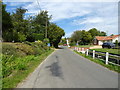
6
Phone Box & Parish Notices
Beside the village name sign along The Street in Poslingford.
Image: © Des Blenkinsopp
Taken: 16 Sep 2021
0.05 miles
7
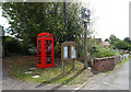
Telephone box on The Street, Poslingford
No longer in use as such.
Image: © JThomas
Taken: 31 Aug 2019
0.05 miles
8
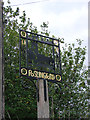
Poslingford village sign
At the top border of the sign is a heavy horse in the pasture representing the importance of the horse before the tractor and mechanisation. On each side are straws of golden wheat symbolic of the arable farming. In the centre panel is the church of St Mary with the trees, just as they are in the churchyard. The tributary of the Chilton Stream is no longer a ford but is represented by the wavy line between the church and the ploughed field in the foreground. The gold ring in each corner, relates to the Poslingford ring, found by a resident in the village while gardening in 1955. It was found to be from the 9th century and is in the British Museum. https://www.geograph.org.uk/photo/6784990
Image: © Adrian S Pye
Taken: 15 Oct 2008
0.06 miles