IMAGES TAKEN NEAR TO
Maxim Lane, SUDBURY, CO10 8FH
Introduction
This page details the photographs taken nearby to Maxim Lane, CO10 8FH by members of the Geograph project.
The Geograph project started in 2005 with the aim of publishing, organising and preserving representative images for every square kilometre of Great Britain, Ireland and the Isle of Man.

There are currently over 7.5m images from over14,400 individuals and you can help contribute to the project by visiting https://www.geograph.org.uk
Image Map
Images are licensed for reuse under creativecommons.org/licenses/by-sa/2.0
Notes
- Clicking on the map will re-center to the selected point.
- The higher the marker number, the further away the image location is from the centre of the postcode.
Image Listing (106 Images Found)
Images are licensed for reuse under creativecommons.org/licenses/by-sa/2.0
Image
Details
Distance
1
![Clare houses [60]](https://s2.geograph.org.uk/geophotos/06/75/74/6757446_a41e185d_120x120.jpg)
Clare houses [60]
Stour House in Stoke Road is early 16th century, timber framed and plastered, jettied to the street with exposed framing and a thatched roof. The house was extended on the left, probably in the 17th century. There is a rear wing. Listed, grade II*, with details at: https://historicengland.org.uk/listing/the-list/list-entry/1031729
The market town of Clare is Suffolk’s smallest town. It lies on the north bank of the River Stour some 12 miles south of Bury St Edmunds and some 7 miles west of Sudbury. Remains of every period since the Palaeolithic have been found in the area. There is a Norman castle, a 13th century Augustinian Priory and a fine, medieval ‘wool’ church as well as many listed buildings, some of which date to the 16th century or earlier.
Image: © Michael Dibb
Taken: 14 Sep 2020
0.07 miles
2
![Clare houses [47]](https://s2.geograph.org.uk/geophotos/06/75/66/6756650_51de244a_120x120.jpg)
Clare houses [47]
Verandah House, number 10 Nethergate Street, is 16th century timber framed and plastered. The windows are early 19th century 'Gothic' with pointed arches. Listed, grade II, with details at: https://historicengland.org.uk/listing/the-list/list-entry/1376689
The market town of Clare is Suffolk’s smallest town. It lies on the north bank of the River Stour some 12 miles south of Bury St Edmunds and some 7 miles west of Sudbury. Remains of every period since the Palaeolithic have been found in the area. There is a Norman castle, a 13th century Augustinian Priory and a fine, medieval ‘wool’ church as well as many listed buildings, some of which date to the 16th century or earlier.
Image: © Michael Dibb
Taken: 14 Sep 2020
0.08 miles
3
![Clare houses [61]](https://s0.geograph.org.uk/geophotos/06/75/74/6757448_64abb709_120x120.jpg)
Clare houses [61]
Riverside, in Stoke Road, is in two parts. The left part is 16th century, timber framed and jettied to the street. The right part is 17th century, timber framed. Both parts are now plastered in rusticated panels. Listed, grade II*, with details at: https://historicengland.org.uk/listing/the-list/list-entry/1285380
The market town of Clare is Suffolk’s smallest town. It lies on the north bank of the River Stour some 12 miles south of Bury St Edmunds and some 7 miles west of Sudbury. Remains of every period since the Palaeolithic have been found in the area. There is a Norman castle, a 13th century Augustinian Priory and a fine, medieval ‘wool’ church as well as many listed buildings, some of which date to the 16th century or earlier.
Image: © Michael Dibb
Taken: 14 Sep 2020
0.08 miles
4
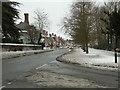
Nethergate Street in Clare, being the A1092
This is the view from the junction with Ashen Road.
Image: © Robert Edwards
Taken: 24 Dec 2010
0.08 miles
6
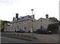
![Clare houses [48]](https://s1.geograph.org.uk/geophotos/06/75/66/6756665_4d5f80b2_120x120.jpg)
Clare houses [48]
Cliftons, number 11 Nethergate Street, is 16th century, timber framed and plastered. A rear wing was added in the 17th century and the house was refronted in the late 18th century when the two flanking wings were added. There is some fine Jacobean and Georgian internal features. Listed, grade I, with details at: https://historicengland.org.uk/listing/the-list/list-entry/1180531
The market town of Clare is Suffolk’s smallest town. It lies on the north bank of the River Stour some 12 miles south of Bury St Edmunds and some 7 miles west of Sudbury. Remains of every period since the Palaeolithic have been found in the area. There is a Norman castle, a 13th century Augustinian Priory and a fine, medieval ‘wool’ church as well as many listed buildings, some of which date to the 16th century or earlier.
Image: © Michael Dibb
Taken: 14 Sep 2020
0.10 miles
7
![Clare features [9]](https://s2.geograph.org.uk/geophotos/06/75/74/6757454_90fab9f7_120x120.jpg)
Clare features [9]
Ashen Road is carried over the River Stour on this cast iron bridge erected in 1813. This bridge was erected only 34 years after the 1st cast iron bridge to be built at Coalbrookdale. It consists of 3 elliptical arches and the soffits of the arches have cast iron ribs. There is another view of the bridge at Image Listed, grade II, with details at: https://historicengland.org.uk/listing/the-list/list-entry/1194234
The market town of Clare is Suffolk’s smallest town. It lies on the north bank of the River Stour some 12 miles south of Bury St Edmunds and some 7 miles west of Sudbury. Remains of every period since the Palaeolithic have been found in the area. There is a Norman castle, a 13th century Augustinian Priory and a fine, medieval ‘wool’ church as well as many listed buildings, some of which date to the 16th century or earlier.
Image: © Michael Dibb
Taken: 14 Sep 2020
0.12 miles
8
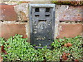
Ordnance Survey Flush Bracket 2051
This can be found on the wall of a house - a private dwelling - in Nethergate Street, Clare.
For more detail see : http://www.bench-marks.org.uk/bm1987
Image: © Peter Wood
Taken: 25 Feb 2015
0.12 miles
9
![Clare houses [49]](https://s2.geograph.org.uk/geophotos/06/75/66/6756670_76d09b8a_120x120.jpg)
Clare houses [49]
Old Court, number 13 Nethergate Street, is the former police station. An early 19th century red brick house with a gault brick front and a Roman Doric portico. Listed, grade II, with details at: https://historicengland.org.uk/listing/the-list/list-entry/1285405
The market town of Clare is Suffolk’s smallest town. It lies on the north bank of the River Stour some 12 miles south of Bury St Edmunds and some 7 miles west of Sudbury. Remains of every period since the Palaeolithic have been found in the area. There is a Norman castle, a 13th century Augustinian Priory and a fine, medieval ‘wool’ church as well as many listed buildings, some of which date to the 16th century or earlier.
Image: © Michael Dibb
Taken: 14 Sep 2020
0.12 miles
10
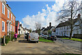
Clare: a spring morning in Nethergate Street
Some of the many Grade II listed historic houses in the town.
Image: © John Sutton
Taken: 13 Apr 2021
0.12 miles