IMAGES TAKEN NEAR TO
Plough Lane, SUDBURY, CO10 2AU
Introduction
This page details the photographs taken nearby to Plough Lane, CO10 2AU by members of the Geograph project.
The Geograph project started in 2005 with the aim of publishing, organising and preserving representative images for every square kilometre of Great Britain, Ireland and the Isle of Man.

There are currently over 7.5m images from over14,400 individuals and you can help contribute to the project by visiting https://www.geograph.org.uk
Image Map
Images are licensed for reuse under creativecommons.org/licenses/by-sa/2.0
Notes
- Clicking on the map will re-center to the selected point.
- The higher the marker number, the further away the image location is from the centre of the postcode.
Image Listing (536 Images Found)
Images are licensed for reuse under creativecommons.org/licenses/by-sa/2.0
Image
Details
Distance
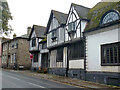
2
Salter's Hall, Sudbury
A grade I listed building, 15th century, with many later additions and alterations, this flint end face is Victorian.
Image: © Robin Webster
Taken: 24 Dec 2013
0.03 miles
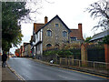
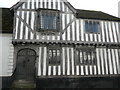
4
The Chantry, Sudbury
A grade I listed building, 15th century, next door to the similarly aged Salter's Hall to the right.
Image: © Robin Webster
Taken: 24 Dec 2013
0.04 miles
6
Detail of the 15C wing of Salter's Hall, Sudbury
This building is listed, Grade I.
Image: © Humphrey Bolton
Taken: 15 Feb 2016
0.04 miles
7
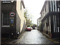
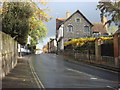
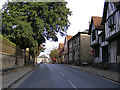
Stour Street, Sudbury
Running by the River Stour
Image: © David Howard
Taken: 14 Mar 2019
0.04 miles
8
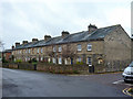
14 - 24 School Street, Sudbury
A terrace of eleven cottages. Every third upper window appears to be bricked up, but as they are centred above pairs of front doors, it seems unlikely they were ever windows.
Image: © Robin Webster
Taken: 24 Dec 2013
0.04 miles
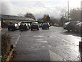
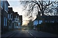
10
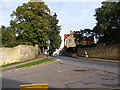
A131 Stour Street, Sudbury
At the junction with Walnut Tree Lane
Image: © Geographer
Taken: 4 Oct 2013
0.04 miles