IMAGES TAKEN NEAR TO
Blackfriars, SUDBURY, CO10 2AQ
Introduction
This page details the photographs taken nearby to Blackfriars, CO10 2AQ by members of the Geograph project.
The Geograph project started in 2005 with the aim of publishing, organising and preserving representative images for every square kilometre of Great Britain, Ireland and the Isle of Man.

There are currently over 7.5m images from over14,400 individuals and you can help contribute to the project by visiting https://www.geograph.org.uk
Image Map (Loading...)


Getting Data...Please wait
Leaflet Map data © OpenStreetMap
Images are licensed for reuse under creativecommons.org/licenses/by-sa/2.0
Notes
- Clicking on the map will re-center to the selected point.
- The higher the marker number, the further away the image location is from the centre of the postcode.
Image Listing (257 Images Found)
Images are licensed for reuse under creativecommons.org/licenses/by-sa/2.0
Image
Details
Distance
1
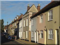
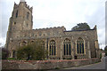
All Saints' church in Sudbury - churchyard
View across the churchyard of All Saints' > http://www.geograph.org.uk/photo/2093948 towards cottages in Church Street (B1116). The large chest tomb in mid-distance marks the mausoleum of the Gainsborough family.
Image: © Evelyn Simak
Taken: 2 Oct 2010
0.01 miles
6
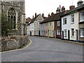
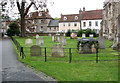
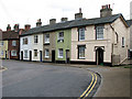
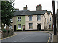
The B1116 road through Sudbury
Here the road circumnavigates All Saint's church > http://www.geograph.org.uk/photo/2093948 the east end of which can be seen at left.
Image: © Evelyn Simak
Taken: 2 Oct 2010
0.04 miles
7
Cottages along the B1116 road through Sudbury
The south-east corner of All Saints' church > http://www.geograph.org.uk/photo/2093948 juts out into the road at left.
Image: © Evelyn Simak
Taken: 2 Oct 2010
0.04 miles
9
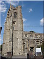
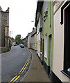
All Saint's Church tower
Picture taken from Church Street.
Image: © Oxyman
Taken: 3 Aug 2007
0.04 miles
10
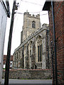
All Saints' church in Sudbury
In the 12th century All Saints' church > http://www.geograph.org.uk/photo/2093948 was part of the Abbey of St Albans but the church as we see it today dates mainly from the 14th and 15th centuries. The chancel predates the rest of the church, dating from the early 1300s. The north aisle was added in the 15th century, serving as a chapel for the Waldegrave and later the Eden family, a painted genealogy of which, dating from 1622, can be seen on the chapel east wall > http://www.geograph.org.uk/photo/2094210. The church, which was used as a prison during the war with the Dutch in 1660, was extensively renovated during the 19th century and the east window > http://www.geograph.org.uk/photo/2094202 and pews with carved poppy heads > http://www.geograph.org.uk/photo/2094220 - the work of a local craftsman called Thomas Elliston - date from this time. The baptismal font > http://www.geograph.org.uk/photo/2094231 is original and dates from the 15th century, the C15 pulpit > http://www.geograph.org.uk/photo/2094199 is described as one of the best examples from the pre-Reformation period and the parclose screen > http://www.geograph.org.uk/photo/2094184 is from this time also.
Image: © Evelyn Simak
Taken: 2 Oct 2010
0.04 miles