IMAGES TAKEN NEAR TO
Elysian Gardens, MALDON, CM9 8QN
Introduction
This page details the photographs taken nearby to Elysian Gardens, CM9 8QN by members of the Geograph project.
The Geograph project started in 2005 with the aim of publishing, organising and preserving representative images for every square kilometre of Great Britain, Ireland and the Isle of Man.

There are currently over 7.5m images from over14,400 individuals and you can help contribute to the project by visiting https://www.geograph.org.uk
Image Map
Images are licensed for reuse under creativecommons.org/licenses/by-sa/2.0
Notes
- Clicking on the map will re-center to the selected point.
- The higher the marker number, the further away the image location is from the centre of the postcode.
Image Listing (35 Images Found)
Images are licensed for reuse under creativecommons.org/licenses/by-sa/2.0
Image
Details
Distance
1
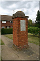
Jeremiah Easter monument, Tollesbury
The monument stands rather incongruously amongst local authority housing in Elysian Gardens. This is the name of a cul-de-sac and the gardens no longer as such exist. The inscription reads:
CREDITO IN DEO. THAT OFFICER WHO ERECTED THIS PILE WAS PRESENT AT THE COMBATS AND BATTLES AT ALBERCHE AND TALAVERA IN 1809 BUSACO RETIREMENT SOBRAL AND LINES AT TORRESVEDRAS IN 1810 FOZ D'AROUCE AND FUENTES D'ONOR IN 1811
These were all "combats and battles" in the Peninsular War of 1807-14 in which British and other forces led by Wellington engaged with Napoleonic forces
Image: © David Kemp
Taken: 3 Jun 2020
0.04 miles
2
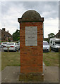
Jeremiah Easter monument, Tollesbury
The monument stands rather incongruously amongst local authority housing in Elysian Gardens. This is the name of a cul-de-sac and the gardens no longer exist as such. The inscription reads:
THE ELYSIAN GARDENS PLANTED IN 1839 AND THIS PILE ERECTED IN COMMEMORATION OF NELSON AND WELLINGTON BY CAPTAIN JEREMIAH EASTER 1852
Image: © David Kemp
Taken: 3 Jun 2020
0.04 miles
3
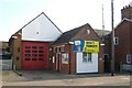
Tollesbury fire station
Tollesbury fire station, 13 High Street, Tollesbury, Maldon, Essex
Image: © Kevin Hale
Taken: 4 Jun 2010
0.08 miles
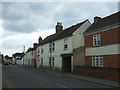
4

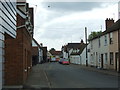
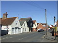
Looking east along the High Street (B1023)
From its junction with North Road.
Image: © John Baker
Taken: 2 Apr 2014
0.08 miles
6
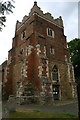
St Mary, Tollesbury - north-west elevation of tower
The base of the tower is C11 and the brick upper extension added c.1600.
Image: © David Kemp
Taken: 3 Jun 2020
0.09 miles
8
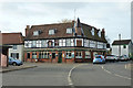
The King's Head, Tollesbury
A grade II listed building from the 17th and 18th centuries, not originally a pub.
Image: © Robin Webster
Taken: 6 Dec 2015
0.09 miles
9
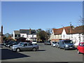
Tollesbury Square
The square in the middle of the village of Tollesbury in Essex.
Image: © Malc McDonald
Taken: 20 Apr 2013
0.09 miles
10
Tollesbury High Street
Tollesbury is a village in Essex.
Image: © Malc McDonald
Taken: 20 Apr 2013
0.09 miles