IMAGES TAKEN NEAR TO
Williams Drive, CM9 6WY
Introduction
This page details the photographs taken nearby to Williams Drive, CM9 6WY by members of the Geograph project.
The Geograph project started in 2005 with the aim of publishing, organising and preserving representative images for every square kilometre of Great Britain, Ireland and the Isle of Man.

There are currently over 7.5m images from over14,400 individuals and you can help contribute to the project by visiting https://www.geograph.org.uk
Image Map
Images are licensed for reuse under creativecommons.org/licenses/by-sa/2.0
Notes
- Clicking on the map will re-center to the selected point.
- The higher the marker number, the further away the image location is from the centre of the postcode.
Image Listing (15 Images Found)
Images are licensed for reuse under creativecommons.org/licenses/by-sa/2.0
Image
Details
Distance
1
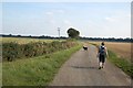
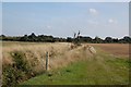
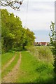
Farm Track
A public footpath follows the route of this farm track from Brookhead Farm towards the former railway line marked by the trees in the distance.
Image: © Trevor Harris
Taken: 21 Sep 2008
0.06 miles
2
Silly Sign
As indicated by the waymarker on the left walkers must leave the track to avoid trespassing. If you keep to the track you end up in Hazleigh Hall Wood, which is not where one might intend to go. The line of trees in the background marks the course of the old West Maldon to Woodham Ferrers railway line.
Image: © Glyn Baker
Taken: 6 May 2016
0.10 miles
3
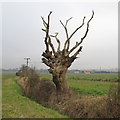
Dead Tree on Field Boundary
Dead tree near a ditch close to Brookhead Farm.
Image: © Roger Jones
Taken: 17 Feb 2013
0.12 miles
4
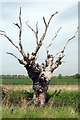
Passed on Pollard
Bereft of life it rests in peace, this oak looks decidedly too middle aged to have shuffled off this mortal coil. It should have been good for another 300 years I wonder why it gave up the ghost?
Image: © Glyn Baker
Taken: 6 May 2016
0.12 miles
5
Footpath from Brookhead Farm
At this point the footpath is approaching the course of the old railway marked by the trees in the distance.
Image: © Trevor Harris
Taken: 21 Sep 2008
0.14 miles
6
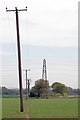
Path & Leaning Power Pole
This path eventually leads to the Image
Image: © Glyn Baker
Taken: 6 May 2016
0.18 miles
7
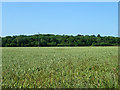
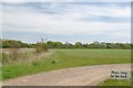
Field of wheat
South of Brookhead Farm.
Image: © Robin Webster
Taken: 21 Jun 2014
0.20 miles
8
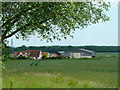
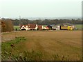
Brookhead Farm
Viewed from a loop of the old route of the main road.
Image: © Robin Webster
Taken: 1 Jun 2014
0.20 miles
9
The Path to Brookhead Farm
Not a bad pic spoiled by a phone or power cable. I was sorely tempted to "photoshop" it out but I am sure I would be eventually caught out by the worshipful Company of Pedants!
Image: © Glyn Baker
Taken: 6 May 2016
0.20 miles