IMAGES TAKEN NEAR TO
Woodham Walter, MALDON, CM9 6SF
Introduction
This page details the photographs taken nearby to CM9 6SF by members of the Geograph project.
The Geograph project started in 2005 with the aim of publishing, organising and preserving representative images for every square kilometre of Great Britain, Ireland and the Isle of Man.

There are currently over 7.5m images from over14,400 individuals and you can help contribute to the project by visiting https://www.geograph.org.uk
Image Map (Loading...)


Getting Data...Please wait
Leaflet Map data © OpenStreetMap
Images are licensed for reuse under creativecommons.org/licenses/by-sa/2.0
Notes
- Clicking on the map will re-center to the selected point.
- The higher the marker number, the further away the image location is from the centre of the postcode.
Image Listing (21 Images Found)
Images are licensed for reuse under creativecommons.org/licenses/by-sa/2.0
Image
Details
Distance
1
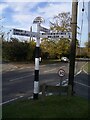
Direction Sign ? Signpost in Woodham Walter
Located on the south side of the junction of Church Hill, Oak Farm Road and Herbage Park Road in Woodham Walter parish. 3 arms and half-moon finial.
Milestone Society National ID: EX_TL8006B
Image: © John V Nicholls
Taken: Unknown
0.03 miles
2
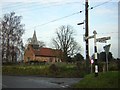
Parish church and signpost at Woodham Walter
A pleasant view marred by the tangle of overhead cables. The signpost was a product of Maldon Iron Works and dates back to the 1920s.
Image: © John V Nicholls
Taken: 9 Jan 2006
0.03 miles
3
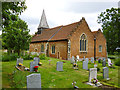
Woodham Walter church
St. Michael the Archangel.
Image: © Robin Webster
Taken: 24 Jun 2013
0.06 miles
4
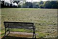
All Seater Stadium?
I don't suppose many spectators have to stand when a footie match is taking place on this recreation ground.
Image: © Glyn Baker
Taken: 6 May 2016
0.06 miles
5
St. Michael; the parish church of Woodham Walter
Apart from the 19th century bell-turret and east window, the church was built in 1563-4 entirely of red brick. The east and west stepped gables are quite Dutch in design.
Image: © Robert Edwards
Taken: 21 Mar 2008
0.07 miles
6

St Michael the Archangel, Woodham Walter, Essex
The oldest purpose-built Church of England place of worship in Britain.
Image: © Peter Stack
Taken: 4 May 2009
0.08 miles
7
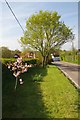
Memorial Garden
This verge is maintained as a Memorial Garden in Memory of those from the village who were killed in WW1. To me a much more fitting remembrance than a lump of stone gathered around once a year.
Image: © Glyn Baker
Taken: 6 May 2016
0.10 miles
8
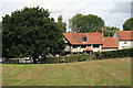
The Bell pub from the Recreation ground
Image: © Paul Franks
Taken: 17 Aug 2018
0.12 miles
9
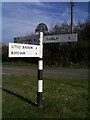
Direction Sign ? Signpost in Woodham Walter
Located opposite The Bell public house on a grass triangle in the centre of the junction of Church Hill, The Street and Little Baddow Road in Woodham Walter parish. 3 arms and half-moon finial. See also https://www.flickr.com/photos/boxster986/7179465246/.
Milestone Society National ID: EX_TL8006A
Image: © John V Nicholls
Taken: Unknown
0.13 miles
10
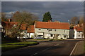
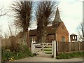
Cottages, Woodham Walter
These cottages beside The Bell (seen on the left behind the tree) are lit by late afternoon sun.
Image: © Trevor Harris
Taken: 15 Jan 2012
0.13 miles