IMAGES TAKEN NEAR TO
Fambridge Road, MALDON, CM9 6PH
Introduction
This page details the photographs taken nearby to Fambridge Road, CM9 6PH by members of the Geograph project.
The Geograph project started in 2005 with the aim of publishing, organising and preserving representative images for every square kilometre of Great Britain, Ireland and the Isle of Man.

There are currently over 7.5m images from over14,400 individuals and you can help contribute to the project by visiting https://www.geograph.org.uk
Image Map
Images are licensed for reuse under creativecommons.org/licenses/by-sa/2.0
Notes
- Clicking on the map will re-center to the selected point.
- The higher the marker number, the further away the image location is from the centre of the postcode.
Image Listing (8 Images Found)
Images are licensed for reuse under creativecommons.org/licenses/by-sa/2.0
Image
Details
Distance
1
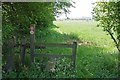
St Peters Way Leaving Fambridge Road
Looking towards Simmonds Lane on the St Peters Way https://www.ldwa.org.uk/ldp/members/show_path.php?path_name=St+Peter%27s+Way
Image: © Glyn Baker
Taken: 12 May 2016
0.09 miles
2
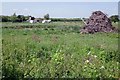
Small Pond and Habitat Pile
In nature conservation when you have too much brash and you don't want to burn it you call it a habitat pile. This heap is probably home to Slowworms and possibly lizards or grass snakes and of course innumerable invertebrates.
Image: © Glyn Baker
Taken: 12 May 2016
0.13 miles
3
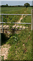
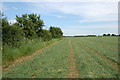
Dried out drainage channel west of Mundon
Taken during a period of drought in May 2011.
Image: © David Kemp
Taken: 24 May 2011
0.15 miles
4
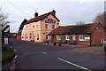
The Round Bush
On Roundbush Lane, although just off the busy B1010 and easily seen from it.
Image: © Robin Webster
Taken: 1 Jun 2014
0.15 miles
5
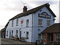
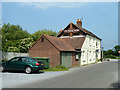
The Roundbush
Pub with a restaurant. There is also a cafe attached.
Image: © Angela Tuff
Taken: 27 Jan 2006
0.15 miles
7
Off route on St Peter's Way
I should have been on the other side of this hedge, not that it mattered much. However, the initial section of the path coming off Simmonds Lane was very over-grown and it was easy to move into the field too soon.
Image: © Trevor Harris
Taken: 9 Jun 2014
0.20 miles
8
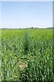
St Peters Way Near Mundon
Looking back towards Sparrow Wycke along the St Peters Way https://www.ldwa.org.uk/ldp/members/show_path.php?path_name=St+Peter%27s+Way
This barley crop is well advanced compared to other crops I have seen in my recent peregrinations.
Image: © Glyn Baker
Taken: 12 May 2016
0.22 miles