IMAGES TAKEN NEAR TO
Highlands Drive, MALDON, CM9 6HY
Introduction
This page details the photographs taken nearby to Highlands Drive, CM9 6HY by members of the Geograph project.
The Geograph project started in 2005 with the aim of publishing, organising and preserving representative images for every square kilometre of Great Britain, Ireland and the Isle of Man.

There are currently over 7.5m images from over14,400 individuals and you can help contribute to the project by visiting https://www.geograph.org.uk
Image Map (Loading...)


Getting Data...Please wait
Leaflet Map data © OpenStreetMap
Images are licensed for reuse under creativecommons.org/licenses/by-sa/2.0
Notes
- Clicking on the map will re-center to the selected point.
- The higher the marker number, the further away the image location is from the centre of the postcode.
Image Listing (21 Images Found)
Images are licensed for reuse under creativecommons.org/licenses/by-sa/2.0
Image
Details
Distance
1
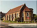
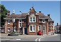
St. Peter's Hospital chapel in Spital Road
The hospital was originally built as a workhouse in 1873. This chapel may be of the same age.
Image: © Robert Edwards
Taken: 7 May 2008
0.13 miles
2
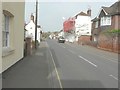
Looking west-northwest along London Road
The house on the right, with scaffolding and red safety netting along its frontage, is number 4.
Image: © John Baker
Taken: 3 Apr 2014
0.13 miles
3
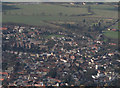
Maldon an aerial view
There is what appears to be a water tower that isn't shown on the OS map at Image All Saints Primary School can be seen just above centre.
Image: © terry joyce
Taken: 6 Mar 2009
0.13 miles
5
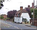
Maldon: weatherboarded cottage in Spital Road
Quite tiny - but I suspect that a century and a half ago there were many more like it in Maldon and the surrounding villages.
The photo was taken in fading evening light. I had passed this little building a few times in recent years - mostly after sunset - and each time I'd promised myself I'd stop next time . . .
Image: © Stefan Czapski
Taken: 15 Sep 2018
0.16 miles
7
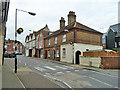
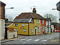
1 - 5 (odds) Fambridge Road, Maldon
A block of three cottages in yellow and red brick, whose appearance as a unit is not helped by paint on part of number 5. This originally had a front door like the others, but mirrored. This has been bricked up and a side door substituted.
Image: © Robin Webster
Taken: 4 Mar 2014
0.19 miles
10
7 and 9 Fambridge Road, Maldon
A grade II listed building from the 17th century, altered and extended later.
Image: © Robin Webster
Taken: 4 Mar 2014
0.20 miles