IMAGES TAKEN NEAR TO
London Road, MALDON, CM9 6HG
Introduction
This page details the photographs taken nearby to London Road, CM9 6HG by members of the Geograph project.
The Geograph project started in 2005 with the aim of publishing, organising and preserving representative images for every square kilometre of Great Britain, Ireland and the Isle of Man.

There are currently over 7.5m images from over14,400 individuals and you can help contribute to the project by visiting https://www.geograph.org.uk
Image Map (Loading...)


Getting Data...Please wait
Leaflet Map data © OpenStreetMap
Images are licensed for reuse under creativecommons.org/licenses/by-sa/2.0
Notes
- Clicking on the map will re-center to the selected point.
- The higher the marker number, the further away the image location is from the centre of the postcode.
Image Listing (8 Images Found)
Images are licensed for reuse under creativecommons.org/licenses/by-sa/2.0
Image
Details
Distance
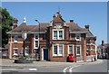
3
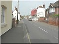
Looking west-northwest along London Road
The house on the right, with scaffolding and red safety netting along its frontage, is number 4.
Image: © John Baker
Taken: 3 Apr 2014
0.19 miles
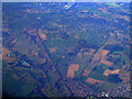
4
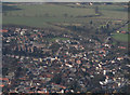
Maldon an aerial view
There is what appears to be a water tower that isn't shown on the OS map at Image All Saints Primary School can be seen just above centre.
Image: © terry joyce
Taken: 6 Mar 2009
0.21 miles
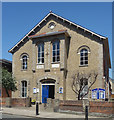
5
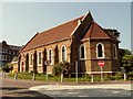
St. Peter's Hospital chapel in Spital Road
The hospital was originally built as a workhouse in 1873. This chapel may be of the same age.
Image: © Robert Edwards
Taken: 7 May 2008
0.23 miles
8
Langford from the air
The route of the former Witham to Maldon railway can be seen heading towards Witham. The Langford reservoirs are on the left.
Image: © Thomas Nugent
Taken: 3 Feb 2012
0.24 miles