IMAGES TAKEN NEAR TO
Basin Road, MALDON, CM9 4RY
Introduction
This page details the photographs taken nearby to Basin Road, CM9 4RY by members of the Geograph project.
The Geograph project started in 2005 with the aim of publishing, organising and preserving representative images for every square kilometre of Great Britain, Ireland and the Isle of Man.

There are currently over 7.5m images from over14,400 individuals and you can help contribute to the project by visiting https://www.geograph.org.uk
Image Map
Images are licensed for reuse under creativecommons.org/licenses/by-sa/2.0
Notes
- Clicking on the map will re-center to the selected point.
- The higher the marker number, the further away the image location is from the centre of the postcode.
Image Listing (89 Images Found)
Images are licensed for reuse under creativecommons.org/licenses/by-sa/2.0
Image
Details
Distance
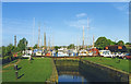
1
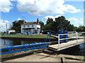
Lock and lock-keeper's house, Heybridge Basin
The last lock on the Chelmer and Blackwater Navigation canal before it enters the River Blackwater
Image: © John Winfield
Taken: 24 Aug 2010
0.00 miles
2

'The Old Ship' inn at Heybridge Basin, Essex
The slope at the side of the inn leads up to a footpath that takes you alongside the basin and on to Maldon town centre.
Image: © Robert Edwards
Taken: 18 Oct 2006
0.02 miles
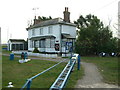
3

'The Jolly Sailor' public house, Heybridge Basin, Essex
This is one of two pubs that stand at the end of Basin Road.
Image: © Robert Edwards
Taken: 18 Oct 2006
0.02 miles
4
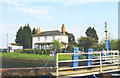
Lock Keeper's House, Heybridge Lock
The lowest lock on the Chelmer and Blackwater Navigation.
From a print. Date approximate.
Image: © Des Blenkinsopp
Taken: Unknown
0.02 miles
5
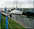
Entering the lock, Heybridge Basin
A busy time at high tide with six yachts attempting to enter the basin, meant the use of the double lock.
Image: © John Winfield
Taken: 29 Aug 2007
0.03 miles
6

Lock gates and lock-keeper's house, Heybridge sea-lock (1)
Looking east from Heybridge Basin. The lock links the Chelmer & Blackwater Navigation to the tidal waters of the Blackwater estuary.
Image: © Stefan Czapski
Taken: 27 Oct 2015
0.03 miles
7
Lock gates and lock-keeper's house, Heybridge sea-lock (2)
Heybridge lock connects the Chelmer & Blackwater Navigation to the tidal waters of the Blackwater estuary.
View from the seaward end of Heybridge Basin, showing the gates at the inner end of the lock.
Image: © Stefan Czapski
Taken: 27 Oct 2015
0.03 miles
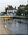
8
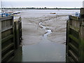
Lock gates at Heybridge
Lock gates open at low tide, looking across the mud at the western end of the Blackwater estuary.
Image: © Ken Walton
Taken: 5 Jun 2004
0.03 miles
9
Heybridge Lock
The bottom lock on the Navigation.
From a print, date approximate.
Image: © Des Blenkinsopp
Taken: Unknown
0.03 miles
10
Lock Keeper's House
The lock keeper's house at Heybridge sea lock on the River Blackwater.
Image: © Robin Lucas
Taken: 5 Mar 2015
0.04 miles