IMAGES TAKEN NEAR TO
Bakers Lane, BRAINTREE, CM77 8QS
Introduction
This page details the photographs taken nearby to Bakers Lane, CM77 8QS by members of the Geograph project.
The Geograph project started in 2005 with the aim of publishing, organising and preserving representative images for every square kilometre of Great Britain, Ireland and the Isle of Man.

There are currently over 7.5m images from over14,400 individuals and you can help contribute to the project by visiting https://www.geograph.org.uk
Image Map (3 Images)


Getting Data...Please wait
Leaflet Map data © OpenStreetMap
Images are licensed for reuse under creativecommons.org/licenses/by-sa/2.0
Notes
- Clicking on the map will re-center to the selected point.
- The higher the marker number, the further away the image location is from the centre of the postcode.
Image Listing (3 Images Found)
Images are licensed for reuse under creativecommons.org/licenses/by-sa/2.0
Image
Details
Distance
1
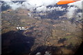
Great Notley, Rayne and Braintree from the air
Great Notley is at the bottom of the photo, Rayne is top left and Braintree is top right. The A120 road runs horizontally through the centre and is joined from the A131 at the large junction in the centre of the photo. Viewed from a Prague bound plane which has just taken off from Stansted Airport.
Image: © Thomas Nugent
Taken: 15 Mar 2010
0.09 miles
2
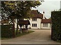
Farmhouse at Card's Farm, near Black Notley, Essex
Image: © Robert Edwards
Taken: 23 Aug 2006
0.17 miles
3
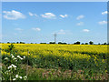
Field of oil-seed rape
South of Baker's Lane.
Image: © Robin Webster
Taken: 27 May 2013
0.22 miles