IMAGES TAKEN NEAR TO
Witham Road, BRAINTREE, CM77 8PA
Introduction
This page details the photographs taken nearby to Witham Road, CM77 8PA by members of the Geograph project.
The Geograph project started in 2005 with the aim of publishing, organising and preserving representative images for every square kilometre of Great Britain, Ireland and the Isle of Man.

There are currently over 7.5m images from over14,400 individuals and you can help contribute to the project by visiting https://www.geograph.org.uk
Image Map
Images are licensed for reuse under creativecommons.org/licenses/by-sa/2.0
Notes
- Clicking on the map will re-center to the selected point.
- The higher the marker number, the further away the image location is from the centre of the postcode.
Image Listing (7 Images Found)
Images are licensed for reuse under creativecommons.org/licenses/by-sa/2.0
Image
Details
Distance
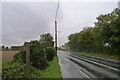
2
The Essex Way 85: Witham Road
The Essex Way emerges onto Witham Road.
Image: © Trevor Harris
Taken: 12 Sep 2010
0.04 miles
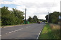
3
Across the Fields to Witham Road
The B1018 from Station Road, White Notley.
Image: © Nigel Thompson
Taken: 18 May 2013
0.04 miles
4
The Essex Way 86: Witham Road
The Essex Way follows Witham Road towards Cressing for a 100 yards or so.
Image: © Trevor Harris
Taken: 12 Sep 2010
0.16 miles
5
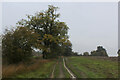
On the Essex Way between White Notley and Cressing
A wet and dismal day on a muddy track adopted by the Essex Way long distance footpath.
Image: © Chris Heaton
Taken: 13 Oct 2020
0.25 miles
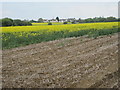
6
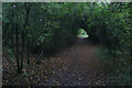
Essex Way heading North East towards Cressing
After leaving the B1018 Whitham Road, the Essex Way heads through a short dark green tunnel before heading across open fields towards the church at Cressing.
Image: © Chris Heaton
Taken: 13 Oct 2020
0.25 miles
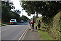
7
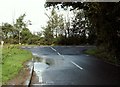
Station Road meeting Witham Road
The road at the end of this junction is the B.1018
Image: © Robert Edwards
Taken: 4 Oct 2006
0.25 miles