IMAGES TAKEN NEAR TO
Pattiswick, BRAINTREE, CM77 8BE
Introduction
This page details the photographs taken nearby to CM77 8BE by members of the Geograph project.
The Geograph project started in 2005 with the aim of publishing, organising and preserving representative images for every square kilometre of Great Britain, Ireland and the Isle of Man.

There are currently over 7.5m images from over14,400 individuals and you can help contribute to the project by visiting https://www.geograph.org.uk
Image Map
Images are licensed for reuse under creativecommons.org/licenses/by-sa/2.0
Notes
- Clicking on the map will re-center to the selected point.
- The higher the marker number, the further away the image location is from the centre of the postcode.
Image Listing (10 Images Found)
Images are licensed for reuse under creativecommons.org/licenses/by-sa/2.0
Image
Details
Distance
1
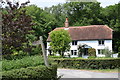
Monkwood House
On the byway to Little Nunty's Farm.
Image: © Trevor Harris
Taken: 2 Jun 2020
0.01 miles
2
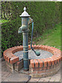
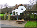
Water pump near Monk Wood Cottage, Nunty's Lane
Working water pump, with "Warners London" inscribed on the spout.
Image: © Roger Jones
Taken: 24 Apr 2013
0.02 miles
3
Monkwood House and pump
The house is a grade II listed building from about 1580 with later alterations. The pump was mapped from at least late Victorian times, and was made by Warners of London.
Image: © Robin Webster
Taken: 7 Feb 2016
0.02 miles
4
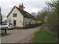
Little Nunty's Farmhouse
Weatherboarded farm house.
Of interest is the Historic Building Record for Little Nunty's Farm by Essex County Council Field Archaeology Unit. See (pdf) http://archaeologydataservice.ac.uk/catalogue/adsdata/arch-439-1/dissemination/pdf/essexcou1-53787_1.pdf
Image: © Roger Jones
Taken: 24 Apr 2013
0.03 miles
5
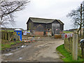
Old barn at Little Nunty's Farm
This appears to be set up for conversion, although not in very good preservation. Several more modern farm buildings have been demolished around it.
Image: © Robin Webster
Taken: 7 Feb 2016
0.04 miles
8
Deer grazing by part of Great Monks Wood
The deer are confident of being to retreat into the wood if they are approached.
Image: © Trevor Harris
Taken: 2 Jun 2020
0.21 miles
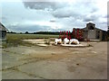
9
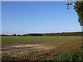
Little Nunty's farm
This arable field was originally divided into 7 and named after the days of the week and during WW II a horse was caught in cross fire from a "dog fight" going on overhead and, alas, died.
Image: © Simon Leatherdale
Taken: 2 Nov 2006
0.22 miles
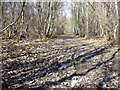
10
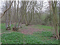
Big Joslins
The interior of Big Joslins wood.
Image: © Roger Jones
Taken: 24 Apr 2013
0.25 miles