IMAGES TAKEN NEAR TO
Great Bardfield, BRAINTREE, CM7 4QW
Introduction
This page details the photographs taken nearby to CM7 4QW by members of the Geograph project.
The Geograph project started in 2005 with the aim of publishing, organising and preserving representative images for every square kilometre of Great Britain, Ireland and the Isle of Man.

There are currently over 7.5m images from over14,400 individuals and you can help contribute to the project by visiting https://www.geograph.org.uk
Image Map
Images are licensed for reuse under creativecommons.org/licenses/by-sa/2.0
Notes
- Clicking on the map will re-center to the selected point.
- The higher the marker number, the further away the image location is from the centre of the postcode.
Image Listing (3 Images Found)
Images are licensed for reuse under creativecommons.org/licenses/by-sa/2.0
Image
Details
Distance
1
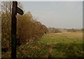
Un-signed bifurcation near Great Bardfield
The sign here must have disappeared quite recently as Google Streetview still shows one. Taken in the lane from Shalford. The other two lanes go to Great Bardfield (left) and Wethersfield (right).
Image: © David Kemp
Taken: 4 Aug 2020
0.14 miles
2
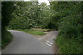
Road near Petches Yew Farm, Finchingfield
Part of the range in the centre of the photograph is the listed building "Oastwood": A mid C18 cottage, altered and extended to the rear and west in the C20.
List entry Number: 1337796 http://list.english-heritage.org.uk/resultsingle.aspx?uid=1337796
Image: © Roger Jones
Taken: 30 Jun 2013
0.16 miles